Vietnam satellite image receiving station is ready
The first satellite image receiving station using Vietnam's remote sensing technology (located in Tu Liem, Hanoi) will be inaugurated by the National Remote Sensing Center and the Ministry of Natural Resources and Environment in early July.
According to Mr. Nguyen Xuan Lam, Director of the Center, human resources for operating this system are ready. In the immediate future, the satellite images will be used for basic investigation, land inventory, forest inventory, seizure of forest fire areas and deforested forest areas . In addition, under conditions Natural disasters and floods, satellite images also help management agencies to capture information in a timely manner from the analysis of photos when unable to arrive at the scene.
He added: 'Currently in Vietnam, satellite images only serve state management agencies. In the future, this technology can be widely applied as a service for private units in housing development, tourism investment . '

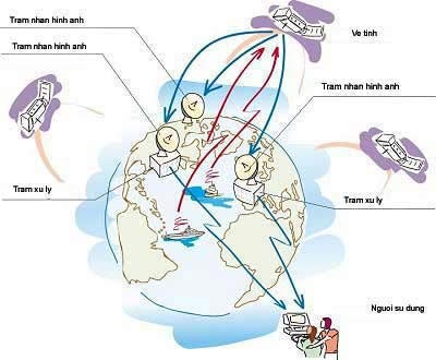
Diagram of satellite system, image receiving station, data processing station and users (Photo: VNN)
- Vietnam will build satellite image receiving station
- In early 2006, building satellite image receiving station
- Vietnam has the first ENVISAT satellite image receiving station in Asia
- Close up of Vinasat-2 satellite on launch pad
- Vietnam is about to launch VINASAT satellite
- Publication of the ghost image of the International Space Station
- Direct: Launching Vietnam's Micro Dragon satellite into space
- Can the German satellite fall to Vietnam?
- Vietnam satellite hits the space station
- Vietnam satellite obtained the first photo
- Vietnam satellite is about to leave the space station
- Vietnam will launch the third satellite in the second quarter of 2013
 Van Allen's belt and evidence that the Apollo 11 mission to the Moon was myth
 The levels of civilization in the universe (Kardashev scale)
 Today Mars, the sun and the Earth are aligned
 The Amazon owner announced a secret plan to build a space base for thousands of people