Vietnam will build satellite image receiving station
In early 2006, Vietnam will start construction of a satellite image receiving station. This is the first satellite photo receiving station in Vietnam. At first, it provided satellite images for free
This satellite image receiving station will be managed by a remote sensing center and included in the 'Natural and Environmental Resource Monitoring System in Vietnam' located in Minh Khai Commune, Tu Liem, Hanoi.
According to Mr. Le Minh - Director of Remote Sensing Center, the purchase of equipment and construction of the factory will be completed in 2006. By mid-2007, the collection station will be tested.
It is known that, with the help and sponsorship of the European Space Commission and France in building the 'Vietnam Natural Resources and Environmental Monitoring System' , the Station will be equipped with 3 systems.
It is a photo collection station consisting of various types of French images and cosmic images of Europe.
The types of satellite images collected will serve to map survey, adjust the national map, evaluate and manage the current land use status; serving forest inventory, crops, monitoring (radar) to change the ground due to natural disasters or landslides .
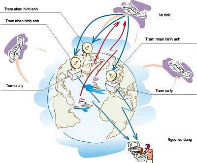
Diagram of satellite system, image receiving station, data processing station and users
In addition, a national data center will be built (located in the Central region) to store and distribute images as required by the industries that need to be used.
In particular, 15 application and data processing and collection centers will be built from satellite images to serve each sector, using remote sensing images such as environmental resources, Agriculture and Rural Development, Fisheries. , Rescue and Rescue Committee, Vietnam Academy of Science .
In the long term, these 15 centers will be photo providers and technological development solutions for provinces and cities nationwide to serve the land inventory and environmental natural resource monitoring of each locality.
With the construction of this satellite image receiving station, many experts have assessed this as a major breakthrough in technology monitoring natural resources and the environment. The station will help Vietnam be more proactive in providing remote sensing images.
Mr. Minh also said that before, when Vietnam did not have a collection station, every year, Vietnam had to spend millions of dollars to buy foreign photos. There are satellite images to buy for $ 4,000 per sheet but still not active in warning natural disasters, earthquakes . Therefore, the development of remote sensing images also allows to gradually replace aviation photos in the currently editing the map and forming thematic maps.
It is known that in the first time, the Center will provide free images, then sell photos to the units to use (estimated at about 1-200USD / photo). So the price is much cheaper than buying from abroad, while the quality is similar. This is good news for those who wish to use remote sensing images.
- In early 2006, building satellite image receiving station
- Vietnam has the first ENVISAT satellite image receiving station in Asia
- Vietnam satellite image receiving station is ready
- Vietnam is about to launch VINASAT satellite
- Vietnam is about to build a nearly 600kg satellite
- Publication of the ghost image of the International Space Station
- Can the German satellite fall to Vietnam?
- Vietnam satellite hits the space station
- Vietnam satellite obtained the first photo
- Vietnam satellite is about to leave the space station
- Vietnam will launch the third satellite in the second quarter of 2013
- The fall of satellites made the Earth
 Vietnam 5th Asian champion on fuel-efficient vehicles
 Humorous Research Wins Ig Nobel Prize 2024
 Singer and songwriter Bob Dylan won the 2016 Nobel Prize for Literature
 We can read all NASA studies completely free of charge