Aere No. 6 storm weakens
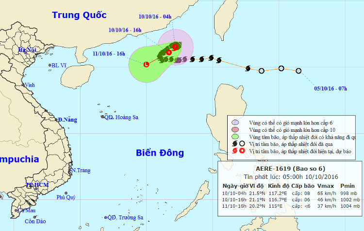
Chapter 04 hours on October 10, the location of the center of the storm at about 21.5 degrees North; 117.2 Kinh Dong, about 350km from Hong Kong (China) to the East of Southeast. The strongest wind is in the area near the center of strong storm level 8 (60-75km / hour), level 9-10.
It is forecasted that in the next 12 hours , the storm will move slowly in the West-South-West direction every 5km, and gradually weaken into a tropical depression. By 16 o'clock on October 10, the position of the tropical depression center is about 21.1 degrees North latitude; 116.7 degrees Kinh Dong, about 690km from Hoang Sa archipelago to the Northeast. The strongest wind in the area near the center of strong tropical depression at level 6 (40-50km / hour), shock level 7-8. Dangerous area (strong wind from level 6 or higher): North of 20N and East of East line 115E.
The path of hurricane Aere.
Due to the impact of the storm, after the tropical depression, the North Sea in the North East Sea has strong winds of level 6, the area near the center of storm level 8, and the shock level of 9-10. The sea is very strong. Disaster risk level: level 3.
In the next 12 to 36 hours, tropical depressions move in the West-South-West direction, 5-10km each hour and weaken into a low pressure area. By 16:00 on October 11, the central location of the low pressure area is about 20.2 degrees North latitude; 115.0 degrees Kinh Dong, about 520 km from Hoang Sa archipelago to the Northeast. The strongest wind in the center of the low pressure area falls below level 6 (below 39km / hour).
In addition, due to the activity of strong southwest monsoon level 4-5, shock level 6-7, in the middle and south of the South China Sea (including waters of the Spratly Islands), the waters from Binh Thuan to Ca Mau , Ca Mau to Kien Giang and the Gulf of Thailand have thunderstorms with strong winds. High waves from 1.0-2.0 meters.
- Aere storm jerks 10-12 levels into the South China Sea
- Aere storm is unpredictable, can cause heavy rain in the mainland
- Aere storms are complicated and unpredictable
- Tomorrow the hot sun peaks at 38 degrees Celsius
- Aere storm entered the South China Sea
- Aere typhoon level 9-10, the East Sea has strong winds
- Severe storms killed 17 Filipinos
- Storm No. 12 weakens into a tropical depression
- Storm No. 1 enters the mainland and weakens into a low pressure
- Storm No. 14 weakens into a tropical depression
- Typhoon Sarika weakens into a tropical depression
- Storm No. 8 weakens into a tropical depression
 Is the magnetic North Pole shift dangerous to humanity?
 Washington legalizes the recycling of human bodies into fertilizer
 Lightning stone - the mysterious guest
 Stunned by the mysterious sunset, strange appearance