Japanese catastrophe through insider insights (1)
The analysis and feel of a Vietnamese scientist working in Japan during the tsunami earthquake, gave another look at this historic event.
Please introduce the analysis of Dr. Ha Ngoc Tuan who is working in Japan on earthquake and tsunami disaster:
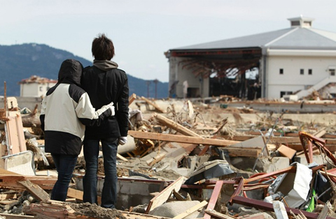
Two Japanese people watch the wildly left behind the earthquake and tsunami in Iwate Prefecture,
northeast Japan, March 17.Photo: AFP
I started writing this article at 13:24 'on March 14, almost two hours after the second explosion at Fukushima I nuclear power plant occurred as a result of the largest earthquake and tsunami in history. Japanese fixtures. This news has been broadcast all over the world and we have seen natural disaster images and the consequences it has caused directly on television.
But it is the images that haunt and cause fears for millions of people around the world when the media only gets its most negative aspects. I am here, in the south of Japan 1,200 km from the epicenter, luckily outside the sphere of influence of the cataclysm that just happened.
It may be that I am somewhat an outsider and calm enough to write this article to my friends near and far.I want to convey to you another message , something that media outside Japan may not mention, as well as technical information that may not always be accessible to you.
East Japan Earthquake
Friday afternoon in Fukuoka city, the spring climate makes my colleagues shout in the office. The radio always muted and flashed news of the time, no one noticed. But at 14:49, everything suddenly changed. News earthquakes and tsunamis on all TV channels.
Less than 3 minutes after the earthquake looked at the TV screen showing a magnitude of 7.9 Richter and the relatively near-shore epicenter occurred at 1446 '. The epicenter location is determined through three measurement points to determine the spatial coordinates, ie the position on the earth's surface and the depth, about 100 km from Kesennuma, a small city. The epicenter of the other city is Rikizentadaka, which is smaller than 20,000 people, within this range. These are the two cities with the closest distance to the epicenter, so it is also the place where the tsunami arises because of the earliest earthquake.
Sendai is about 130 km away from Sendai city with a population of about 1 million people. Fukushima is another big city, although its center is inland without being affected by tsunamis, but two atomic power plants here located on the coast, about 140 km from the epicenter, have been affected. heavily influenced by earthquakes.
All of the above population centers are scattered in the three provinces of Iwate, Miyagi and Fukushima, which are heavily devastated by tsunamis and earthquakes. Tokyo and Chiba are 370 km away from the epicenter, along the route of flying birds, but there is no damage caused by the tsunami.
In the first announcements, the Japan Hydro-Meteorological Agency (JMA) called this earthquake Sanrikuoki the name of the sea where the epicenter was located. This name was immediately overshadowed by the size of the earthquake. Japanese media is now called Higashinihondaizishin (meaning East Japan earthquake).
Warning of earthquakes and tsunamis is not strange if you live in Japan.This happened like here. Moreover, the Japanese tsunami warning system is very modern, only the waves of several tens of centimeters are reported and clearly reported at what hour.
JMA's confusion
But last Friday everything was different. For the first time I witnessed the Japan Meteorological and Hydrology Center (JMA) confused with the exact magnitude of the earthquake and tsunami height. After more than two days, the JMA recalculated the magnitude to 9.0 Richter, although figures 7.9, 8.4 and 8.8 were given. Anyone who has ever worked in seismics probably knows how big the difference between a Richter unit is. To understand this, illustrate the following figure.

The horizontal axis of the graph above indicates the magnitude of an earthquake in Richter units. We can see in this scale the largest seismic battle up to 9.5 Richter scale.This is the largest earthquake recorded in human history, occurring in the Chilean sea on May 22, 1960.
To give you a better picture of the magnitude, please point out that the Sumatra tsunami in Indonesia with a magnitude of 9.1 on the Richter scale occurred in 2004, killing 230,000 people over 14 countries facing India. Ocean There is no 10-magnitude earthquake, because an earthquake with that energy will be global and can erase life.
The vertical axis to the right of the graph shows the energy that the earthquake releases around with joule (J). Thus a 3.5-magnitude earthquake has energy equivalent to an explosion of a ton of TNT.
That day the JMA was confused when making an initial calculation of 7.9 Richter. Then about 2 hours in the Japanese Prime Minister's speech that number was adjusted to 8.4 Richter scale and after more than 2 days, the 9.0 degree Richter figure was officially closed.

Thus, even at the first moments of the magnitude of the tremor, it may have puzzled the JMA, an agency that has the best system of measuring, calculating and warning earthquakes and tsunamis in the world. Such negative assessments. This alone signaled the problem of the recent disaster.
World media using USGS seismic results said that the recent earthquake had a magnitude of 8.9 on the Richter scale. Thus, the East Japan earthquake, whether it was 8.9 or 9.0 on the Richter scale, has reached the top of the largest earthquakes in human history.
Dense seismic and warning system
It can be said that Japan has the most dense seismic measurement system and network in the world. In addition to the meteorological professional monitoring networks, Japan also has other independent monitoring networks that even ordinary people can access. Kyoshin net is an example. A network like this has hundreds of accelerators spread across continents and Japanese terraces. It allows you to monitor background acceleration in any real time if you access the system.
Japan has such a system is not surprising. This sunrise country is located on the intersection of four continental segments, respectively the Pacific Plate, North America, Eurasian and the Philippines. It can be said that this is the hottest place of the so-called ' Ring of Fire ' where tectonic activities that are more specific than collisions of local arrays cause continuous earthquakes in the mainland and seabeds of Japan. .
As we can see in the image above, the route of four continental segments intersects Japan. They move relatively sensitive at very small speeds (by the speed of your nail growth). However, over time the enormous energy (pressure) accumulates in the bedrock at these intersection lines and when that pressure exceeds the intensity of the underground base rock, this rock will burst and release. its potential in kinetic energy is seismic waves.
The March 11 earthquake was the result of such an event due to the interaction of the two continents of North America and the Pacific. Because it is located on this fire belt, Japan suffers continuous seismic strikes and needs a seismic industry with development monitoring systems for disaster prevention and mitigation.
Along with this seismic monitoring system, Japan developed a tsunami warning system.When discovering an epicenter in the sea, thanks to a quick simulation calculation tool plus sea measurement devices, JMA can issue a warning within minutes. These warnings in the form of visual maps show the location of the epicenter of the coastal areas with tsunamis and wave heights.
This information is transmitted directly to television channels, radio stations, and mobile phones so that people quickly leave the coast when there are high waves. All that process from the time of the earthquake came when people realized the danger in just a few minutes. Alarms with loudspeakers and sirens are also carried out in coastal areas, patrol cars along the coast will call people away from the shore. A network of coastal security cameras will connect online with television to monitor the situation of incoming waves.
Movements of tsunami
At 14h51 ', the radio screen switched to live images from Iwate coastal cameras. Now everything is still on the screen, in the first minute the wave height along the coast of Iwate Prefecture is 3 meters, Miyagi is the highest forecast of 6 meters and Fukushima is 3 meters.
Based on the distance from the epicenter to the cities and residential areas mentioned above, it is possible to calculate the wave propagation velocity of about 400 to 500 km / h. In fact, the recent tsunami spread to the US, the other side of the Pacific Ocean was about 8000 km from Japan in 10 hours. If calculated on this long distance, the wave propagation rate can reach 800 km / h. If you take off in Japan when you have an earthquake and fly to the west coast of the US, you will catch the last wave.
But everything changed in a few minutes. Kurokawa, the long-time architect who sat near the screen, exclaimed, "What is the forecast turning into 10 meters?" '. This time it was 15:00 ', the NHK television camera turned up close to a bridge in Kamaishi, a small city in Iwate Prefecture. Now at a narrow angle at the foot of this urban expressway, people can see cars and many other things floating like foam boxes.
My first reaction was to call my wife's mobile phone, the pregnant woman was about to give birth to my alcoholic daughter. My wife knew about me or was curious about the news on television. Many times before there was a tsunami warning in the house, I could only look at the TV to see what the tsunami looked like when it came ashore and it was only a few tens of centimeters every time. But this time it was different, I told my wife: "I turn on the television and watch the big earthquake ."

Put down the phone tube when the boat is on the screen where it suddenly floats back into the city, hitting the bridge through it in a state of reclining. It was possible to see some drivers driving the trucks on the bridge stopped to watch the water rushing under the bridge where a few minutes ago the city and the road suddenly became a river. Finally, a large house floated through the bridge. Perhaps those who stand on the bridge have experienced a more horrifying phenology than any scene that American action films often create.
Tsunami or tsunami as the Japanese way of calling began to devastate the entire northeastern coast of Japan from 3pm on March 11. By now the forecast numbers were different, with the wave heights of Iwate and Miyagi reports all over 10 meters. It must also be mentioned that in the JMA warning scale, 3-meter high waves have been listed in very large waves.
Terrible destructive power of tsunamis
Perhaps the first images in Kamaishi that NHK obtained were too shocking to the station reporter, who immediately took off from television centers with dedicated helicopters. Because of that, the whole world has witnessed directly the scare scene when tsunamis devastated the city and villages in northeastern Japan.
After the live broadcast in Kamaishi is the tsunami panoramic into the coastal plains of Sendai. All of us may have seen the sight of the black-headed water above it, houses, cars and countless pieces of wood that might have been torn from houses pulled into the Sendai city field.
Speed spread on land if compared with the speed of some cars rushed off the wave when running toward the continent about 30 to 40 km / h. Although it was not as fast as the speed of spreading out at sea, it was fast enough to chase after any of the remaining inhabitants in the village where it came.
The Sendai wave swept through the sea dike, spreading quickly into the fields, swallowing the farmers' plastic garden houses, approaching the highway, bouncing when hitting the dike and mixing all the objects it carried on its head. . It felt like cars in the wave were even lighter than matchboxes.
From the live broadcast, some of the ill-fated people could not drive away from the wave right on the highway, which was a few kilometers from the coast, which made the driver not aware of what was happening. out around me. The northeast coast of Japan within 4 hours was wiped out, crushed into huge piles of garbage. There is no urban silhouette, only a whole area is ruined with surviving reinforced concrete houses.
Even in the afternoon, petrochemical complexes caught fire, bridges collapsed, roads were deep in the sea. Many fishing vessels and large payloads were swept into the city. Cars stacked up in a fire. The Japanese city looks exactly the same after the atomic explosion of Hiroshima and Nagasaki. Worse, it is deeply submerged in water and mud due to wide-scale subsidence.
Distribution of earthquakes and aftershocks
The giant earthquake that just shook the whole Japanese territory, but probably did not affect Vietnam because it did not transmit to our country. In other words, the intensity of earthquakes in Vietnam is zero so we do not feel this shock.
Different from the magnitude (magnitude) measured by Richter, assessing the total energy released from the earthquake as discussed above, the intensity or intensity is the measure of the influence of the battle. that earthquake on a certain monitoring point.
The entire northeastern region of Japan (in fact, all of Japan) measured tremors with different intensity. The maximum observed intensity in the last season is 7. This is the intensity of Japanese drama scale. Tokyo suffered from a 5+ intensity, and 3 provinces of Iwate, Miyagi and Fukushima inspired 6+.
In order for readers to get images of intensity 5+, I would like to describe as follows. In 2004, an earthquake occurred in the city where my family was living then, its intensity in my home area was 5+. When an earthquake occurred, it felt like a flock of African wild cattle ran past the house.Everything shook, and the furniture on the floor fell to the floor, and the lights shook and the windows shook.
A Japanese scale level 7 earthquake will shake the ground under the feet of the person so much that he will fall down because he cannot stand with such a fluctuation. Symbolically, when there is a level 7 earthquake, a house will be subjected to a horizontal force of at least half the weight of the house. Or if you weigh 60 kg, you will get a 30 kg push. And note that the background oscillation is constantly changing so the fact that you will be pushed continuously with that force.
Above is the concept of earthquake level and equivalent ground acceleration. In fact, in the last pile of land, the instantaneous ground acceleration data in Kurihara city in Miyagi prefecture was amazing, with its maximum value of 2,933 gal, 3 times the gravitational acceleration. With this acceleration it is difficult to create an artificial structure that can stand. If you weigh 60 kg you will get a constant 180 kg of pulling force.
You may have an image of an earthquake that is a strong shake and then everything ends. The event is not really like that. Those who have experienced large earthquakes like in Japan will have a completely different view.An earthquake, especially a large earthquake, will be accompanied by aftershocks that are smaller earthquakes for days and even years afterwards.

The recent earthquake had a considerable number of aftershocks as well as a considerable amount of aftershocks. In less than an hour after the main match, there were 3 aftershocks greater than 7 Richter. It is worth mentioning that a match of more than 7 degrees has been classified as a big earthquake. Remember in 1995 the catastrophic earthquake in Kobe was only 7.3 centimeters large.
Three days after the main earthquake, observations showed that 200 aftershocks occurred. Thus, on average there are 3 matches in an hour. However, statistics show that most aftershocks occur in the early morning and late afternoon in the past three days. You can still take a nap without being awakened by the earthquake!
Calculating the aftershocks greater than 7 on the Richter scale can happen again within the next few days with a probability of up to 40%. Perhaps with a scale earthquake this aftershock will take place in the next few years. Aftershocks only terminate when the pressure balance (stress) is established in the fracture. The rock will be deformed after the earthquake. Observations discovered that Japan has now moved 4 meters due to the recent earthquake.
With all that happened due to the main earthquake and tsunami and continuous shocking shocks due to aftershocks, even the strongest spirit must be tired of being in an earthquake like this one.
* Continue
- Robots can be home-grown
- Science warns: The Earth is falling into a catastrophe comparable to a nuclear bomb
- Shivered by the 'catastrophes' that almost caused humanity to be wiped out
- It is clear that the cause of the Earth is continuously suffered from meteorites
- A beautiful set of photos about Vietnamese peoples in American newspapers
- Why do Japanese people leave children walking and playing alone without adults?
- Early signs of Japanese encephalitis
- 8 interesting things about Japanese banknotes and coins that Japanese people still don't know
- Prevention and treatment of Japanese encephalitis
- Discover the magic number 5 in Japanese culinary culture
- Interesting surprises about the Japanese family
- Japanese encephalitis on the top of the epidemic
 Is the magnetic North Pole shift dangerous to humanity?
 Washington legalizes the recycling of human bodies into fertilizer
 Lightning stone - the mysterious guest
 Stunned by the mysterious sunset, strange appearance