Advantages of turning Irma into super storm
The formation, warm water and prolonged high pressure blocks are the conditions that nurture Irma into the largest super typhoon in the Atlantic.
Hurricane Irma strengthened into a Category 5 storm on the Atlantic, with maximum winds of up to 295km / h. according to Live Science. This wind caused the storm to fall into a particularly rare group. Historically, only four other storms in the Atlantic have winds of 295 km / h or more, according to Phil Klotzbach, a tropical meteorologist at the University of Colorado, USA.
Irma observes from NOAA's weather satellite.(Video: Twitter).
Hurricanes in the same group as Irma include Typhoon Wilma (2005), Hurricane Gilbert (1988) and an unnamed storm hitting the Florida Keys (1935). Hurricane Allen (1980), reaching a speed of 306km / h, recorded a record of Atlantic wind winds. Typhoon Allen added to northern Mexico, but also affected Haiti and southern Texas, killing nearly 300 people.
The common point between Typhoon Irma and Allen is that they all originate from Cape Verde. Cape Verde storms are typhoons formed in the form of tropical depressions, about 965 km from Cape Verde islands in northwestern South Africa. They became storms before reaching the Caribbean, according to the US National Hurricane Center (NHC). On average, there are two Cape Verde storms each year, most likely to form in August or September.
Irma watched from the International Space Station.(Video: NASA).
Time and warm water
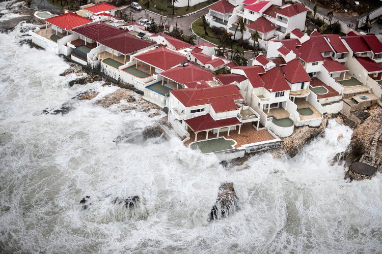
Irma storm devastated many homes in St.Maarten.(Photo: AP).
Not all storms off Cape Verde are strong, according to Neal Dorst, a meteorologist at the US National Oceanic and Atmospheric Administration's Bureau of Storm Research. The warm water evaporates, providing energy for the air cycle of the storm, thereby controlling the storm.
At the peak of the hurricane season from the end of August to the beginning of September, ocean heat is enough to nourish strong typhoon level 5 (with a wind speed of at least 252 km / h) in almost anywhere in the heat zone. Atlantic Ocean. For example, Typhoon Camille was just a tropical depression when it moved to Cuba on August 14, 1969. But warm waters in the Gulf of Mexico made Camille strong into a Category 5 hurricane when it hit Mississippi on August 18, 1969.
But Typhoon Cape Verde has the potential to grow especially because the location in the far east allows storms to have more time to accumulate energy before flooding the land, Dorst said. "They have almost a week to become stable and strengthen their strength. That's why these storms are so bad," Dorst said.
How did Irma storm form?
A storm like Irma was originally just an atmospheric turbulence off the coast of West Africa. There are about 60 atmospheric disturbances appearing every year, and most of them are weakened and dissolved without changing into any more powerful form. But when conditions are met, there is a lot of moisture in the air, heat in the ocean and there are not many winds moving to disrupt the gas circulation, disturbed flows can be strengthened into tropical depressions. , with wind above 40 km / h. When the wind rises 63 km / h, the low pressure becomes a tropical storm. At 119 km / h, tropical storms turn into Atlantic ocean storms.
Irma moved continuously along the Atlantic Ocean due to the continuous high pressure of the north, not only pushing Irma from east to west but also contributing to the storm. When the storm absorbs hot and humid air from the ocean surface and concentrates water vapor into clouds, it must release the compressed air above. The high pressure system is the assistant to help Irma do that.
Super typhoon Irma is expected to be strong at level 4 or level 5 if it landed in Florida on September 10. Storms can cause waves as high as 3 m while Florida's offshore island area is only about 1.8 m above sea level. Previously, the biggest super typhoon on the Atlantic has caused at least 10 deaths when sweeping the islands of Barbuda, St Martin and St Barts on the Caribbean Sea. The number of casualties forecast to continue to increase due to the path and the destructive power of the storm.
- The destructive power of the storm
- Super typhoon Irma, the strongest in 30 years, is about to attack the United States
- The trail of devastating super typhoon Irma left Florida
- Video: 30 seconds looking back on the 10-day journey of super typhoon Irma
- Irma super typhoon has a time of nearly 1,300km
- Florida after super typhoon century Irma: Dark, flooding and ruin
- The world's most dangerous airport was devastated by the typhoon Irma
- Photo: Death storm Irma landed on Florida, causing casualties for Americans
- The 10 biggest storms recorded in history
- Stadium effect in the eye of storm
- The most intense super typhoons in the history of the Atlantic
- Hurricane Irma drained seawater, a rare phenomenon of surreality
 Is the magnetic North Pole shift dangerous to humanity?
 Washington legalizes the recycling of human bodies into fertilizer
 Lightning stone - the mysterious guest
 Stunned by the mysterious sunset, strange appearance