Capture the world's largest satellite image missing
The European Space Agency (ESA) said that on April 15, the French Pleiades observing satellite captured the image of Envisat's largest observation satellite, lost contact since April 8. by. The photo was recorded when two satellites flew about 100km apart.
>>>The world's largest earth observation satellite is missing

Envisat satellites looked quite clear in the photo recorded by the Pleiades satellite on April 15
The Pleiades satellite captured Envisat's body parts, solar battery wings and antennae. ESA is currently analyzing images to determine whether its solar panels are oriented towards the sun. If it is in the right position, the battery can still provide enough power to make the satellite safe to operate, meaning that it can be contacted again.
Volker Liebig, director of ESA's Earth Observation Program, said on Space.com: 'The international cosmopolitan community is still continuing to collaborate to track our lost satellite signals.'
Earlier, a ground radar station operated by Fraunhofer Institute of High-Frequency Physics and Radar Engineering in Wachtberg (Germany) also captured the image of Envisat, on April 10. Universe experts hope these photos will help them determine the direction of flight of the world's largest observation satellite.
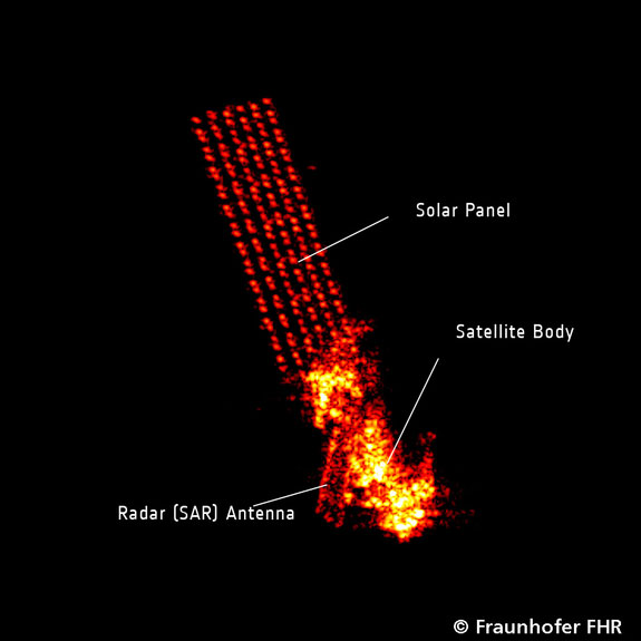
The image of Envisat was recorded by the ground radar station in Wachtberg (Germany) on April 10
Meanwhile, the US Strategic Command's Joint Space Operations Center (JSpOC), is tracking Envisat's trajectory to test whether it falls off Earth's orbit. ESA said that some other ground observation stations are also tracking Envisat's orbit.
The satellite observing Envisat was launched by ESA on Earth orbit in February 2002. This $ 2.9 billion satellite is equipped with 10 of the most modern radar and optical sensors that help it observe and monitor soil, atmospheric, ocean and ice changes on the left. land.
Reference: Space
- Found NASA satellite missing 12 years in the universe
- The world's largest earth observation satellite is missing
- For the first time in the world, Russian satellites have created an image of Earth in 4K format
- In early 2006, building satellite image receiving station
- South Korea: Satellite is missing immediately after launch
- Vietnam will build satellite image receiving station
- Russian military satellites are mysteriously missing
- NASA announces the best satellite image in 2011
- Alphasat has entered the position
- Take pictures from space capture the situation on the ground
- Japan 's 273 million dollar black hole satellite is missing
- If a 'million dollar' satellite suddenly disappears, what will NASA do?
 Van Allen's belt and evidence that the Apollo 11 mission to the Moon was myth
 The levels of civilization in the universe (Kardashev scale)
 Today Mars, the sun and the Earth are aligned
 The Amazon owner announced a secret plan to build a space base for thousands of people