Confusing photos of volcanoes from space
In the image of the Landsat 8 satellite, the long white streak above Mount Michael is difficult to distinguish as a special cloud or a regular plume of smoke.
Michael , an active stratovolcano nearly 1,000 meters high, is more familiar to penguins than to humans. This mountain is located on Saunders Island in the South Sandwich Islands, about 1,600km from Antarctica and 2,400km from South America, surrounded by no settlements. When observed from space by satellite, the mountain is often obscured by clouds.
In this November 7 image taken by the Landsat 8 satellite, the highlight is a long bright white streak that appears above the island. This could be a column of smoke from Mount Michael or a type of cloud called a "volcanic trail".
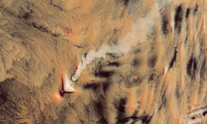
Landsat 8 satellite photographed volcano Michael, Saunders Island. (Photo: Lauren Dauphin/USGS)
Volcanic trails occur when passing clouds interact with gases and particles ejected from volcanoes. These particles create more cloud droplets, making the cloud appear brighter. "As the cloud moves over the volcano, the imprint of these droplets remains in the cloud, looking like a stream or road with an unusual texture when viewed from above , " said Santiago Gassó, a gas scientist book at NASA, explained. Gassó regularly hunts for volcanic lines in satellite images and is the one who discovered the white streak in Landsat 8 images.
In natural color photos, it is difficult to recognize the volcanic trail. The Landsat 8 satellite image is a pseudo-color, created from a combination of short-wave infrared with blue light, which distinguishes it from the rest of the cloud layer.
Volcanic trails are a useful tool for scientists to detect weak volcanic activity such as the eruption of water vapor, small particles and gases. These activities are very common but often go undetected because eruptions often occur under or within clouds. By studying clouds around such weak volcanoes, scientists can learn more about cloud formation and growth.
However, it is also possible that material from Mount Michael on November 7 rose above the cloud, meaning this is just a typical volcanic plume, not a volcanic trail. There is no LiDAR data to measure the height of the white trail, so it is not possible to determine whether this is a volcanic trail or a plume of smoke.
" The Landsat satellite image contains a lot of detail. I observed a few shadows indicating that what I thought was a volcanic trail might just be a plume of smoke just above the cloud, low enough to cast a slight shadow. But It's also unusual for the plume of smoke to maintain such a structure above the cloud layer without dispersing or spreading," Gassó said.
In addition, in the satellite image there is a porous white lenticular cloud. This type of cloud is not associated with volcanic activity. They can develop at the crest of atmospheric waves, forming when winds encounter a terrain barrier and have to change direction upwards.
- See active volcanoes around the world
- New evidence reveals volcanoes are active on Venus
- Can accurately guess the time when volcanoes are active
- Scary volcanoes are more than meteorites
- See the American volcano spray from the universe
- Scary warning about the giant volcano
- NASA announced photos of the earth from the most beautiful space in 2013
- Uncover the mysterious veil of volcanic ranges underneath the Coral Sea
- Discover ancient ice volcanic shock around the dwarf planet
- 100 beautiful, unbelievable photos, never before photoshop
- 'Ice volcano' erupts along the lake
- The photos surprise you because you can't believe it's real
 Van Allen's belt and evidence that the Apollo 11 mission to the Moon was myth
 The levels of civilization in the universe (Kardashev scale)
 Today Mars, the sun and the Earth are aligned
 The Amazon owner announced a secret plan to build a space base for thousands of people