Determine oil fields with satellite images
A map of Earth's gravity based on satellite measurements will make it easier to find new oil fields. This map will become particularly useful when ice melts in the oil-rich Arctic region. Ole Baltazar, an aging scientist at the National Space Academy, Technical University of Denmark (DTU Space), directed the development of this map.
The US company Furgo, one of the world's largest oil exploration and search companies, used this gravity map. The company has now begun collaborating on research with DTU.
Li Xiong, vice president and geophysicist at Furgo, said: 'Ole Baltazar's gravity map is the most accurate map and has the widest coverage to date. With high resolution and accuracy, this map is particularly useful in coastal areas, where most oil fields are concentrated '.
Satellite measurement for high accuracy
Ole Baltazar's map shows changes in gravity on the surface of the Earth and knowledge of small changes that are valuable tools in oil exploration and search. Underground oil fields contain fairly light materials such as limestone and clay.Because these materials are light, they have lighter gravity than the surrounding materials.
Ole Baltazar's map is based on satellite measurements and has unprecedented accuracy and detail. With this map in hand will be easier for the search for oil fields in the ground.
Climate change reveals new sea areas
The gravity map of DTU is particularly at a resolution of only 2 km and the fact that it covers both the sea and land areas. Oil companies use this map in the first exploration step. In the past, potential areas were often selected through the use of extended and expensive measurements using airplanes or ships. These areas appear very clearly on the map and companies can plan exploration more effectively.
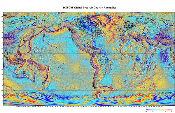 The map shows the gravitational changes on the surface of the Earth and the knowledge of these small changes that are valuable tools for exploration and search of oil. (Photo: DTU).
Ole Baltazar explains: 'This map will become very valuable when the Arctic begins to melt, revealing large seas where there will most likely be many large oil fields below. With our maps, companies can quickly start drilling oil in precise locations without having to make expensive exploration. '
Based on altitude measurement instead of directly measuring gravity
The success of gravity tables is largely due to the fact that it is not based on direct gravity measurement but on observations of the height of the sea, the factor that reflects gravity.
Ole Baltazar explains: 'Elevation measurement has the advantage that it is possible to determine the local gravitational field and thus create gravity maps with a resolution of only a few kilometers. In that gas, the normal resolution when measuring gravity from satellites is 200km. The method of measuring gravitational gravity is used to explore deeper stratigraphic conditions in the Earth's heart, but it is not suitable for our purpose. '
- Earth through satellite images
- Vietnam successfully processed satellite remote sensing images
- The most authentic series of images about Pluto has just been announced
- Latest images of Vietnam taken from outer space
- Satellite images denounce climate change that changes the Earth
- The transformations of the Earth through satellite images
- See each roof from the universe
- Review NASA photos to see how terribly the Earth has changed
- Search for aircraft MH370 via satellite images
- Satellite images detected 1,000 dangerous points on the central highway
- Use satellite data to detect ancient tomb theft
- Japan launched a satellite that could identify 1m objects, take night photos
 Is the magnetic North Pole shift dangerous to humanity?
 Washington legalizes the recycling of human bodies into fertilizer
 Lightning stone - the mysterious guest
 Stunned by the mysterious sunset, strange appearance