Vietnam successfully processed satellite remote sensing images
VNREDSat-1 satellite provides remote sensing images with technical features comparable to those of small satellites in the world, and is able to replace some high-resolution remote sensing images currently on the market.
Ministry of Natural Resources and Environment has just officially announced the acquisition and successful processing of images from the first remote sensing satellite VNREDSat-1."Vietnam has become one of 5 countries in Southeast Asia claiming to own remote sensing satellite together with Thailand, Singapore, Malaysia, Indonesia" , said Nguyen Xuan Lam, Director of the National Remote Sensing Department said and gave Knowing that it is only within 24 hours, the Department will provide photos in the right place.
Mr. Lam said, since being put into orbit, VNREDSat-1 has captured nearly 22,000 scenes, including nearly 6,000 photos of Vietnamese territory. These remote sensing images have been used recently to serve some projects in and outside the natural resources and environment sector. Remote sensing images feature the equivalent of remote sensing images of small satellites in the world and are capable of replacing some high-resolution remote sensing images currently on the market.
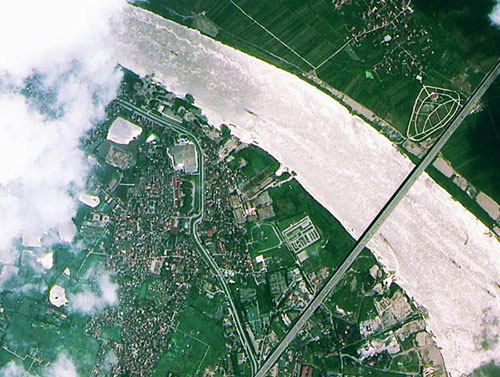
Thanh Tri Bridge of Hanoi by the first remote sensing satellite in Vietnam taken in May last year.(Photo: VNA)
Photos provided by VNREDSat-1 have a resolution of 2.5m for full-color images (white, black) and 10m for multi-spectral image channels (color images). From multi-spectral channels and full-color images, it can be processed to provide natural color images of 2.5m resolution and integrated color photo plans for interpretation of specialized subjects at the request of professionals. family. The satellite also allows for images with a 3-day repeat cycle with an image coverage of 17.5 km x 17.5 km.
According to representatives of the Remote Sensing Department, in the coming time, data collected from satellites will continue to be applied in monitoring environmental resources, such as the project "National Census and Forest Inventory for the period 2012- 2015 Ministry of Agriculture and Rural Development " ; The project "Supervising a number of key offshore islands by remote sensing technology in service of socio-economic development and ensuring security and defense".
The Remote Sensing Department said that the price of the photo will be issued by the Ministry of Finance. In the meantime, the Department serves photo applications for other scientific programs with prices ranging around 5-6 million VND per scene.
Previously, domestic units could order satellite images, but when the Central Remote Sensing Station and the National Remote Sensing Department were available, the Ministry of Finance assigned the Remote Sensing Department to synthesize the needs of the photos of the ministries. sector, then subtract the part VNREDSat-1 meets, the rest will be funded by the state to buy photos for the ministries and branches.
Experts assess that the use of remote sensing photo station managed by the Ministry of Natural Resources and Environment combined with small satellites managed by Vietnam Academy of Science and Technology will save a considerable amount of funding. books developing space technology and remote sensing.
- Vietnam will have a second remote sensing satellite
- VNREDSat-1 satellite leaves the launch pad successfully
- VNREDSat-1 satellite images fly into space
- Simulation of the journey of Vietnam remote sensing satellite
- Complete remote sensing system to monitor Hoang Sa and Truong Sa
- VNREDSAT-1 will be launched in the morning of May 7
- Vietnam's first remote sensing satellite is about to enter the universe
- Defer launch of VNREDSat-1 satellite because of rain
- Why doesn't Vietnam have satellite remote sensing?
- Vietnam is about to have a second remote sensing satellite
- Vietnam satellite image receiving station is ready
- 2014: Vietnam will launch satellite remote sensing
 Vietnam 5th Asian champion on fuel-efficient vehicles
 Humorous Research Wins Ig Nobel Prize 2024
 Singer and songwriter Bob Dylan won the 2016 Nobel Prize for Literature
 We can read all NASA studies completely free of charge