Why doesn't Vietnam have satellite remote sensing?
In addition to telecommunication satellites (Vinasat) expected to launch the orbit in 2008, the project of applying and developing remote sensing technology in Vietnam by 2010 is also expected to launch a remote sensing satellite into the orbit of the year. 2005. So far, how far is the implementation of the project?
 Mr. Tran Cong Du, Deputy Director of Department of Science and Technology of economic and technical sectors (Ministry of Science and Technology), said:
- In July 2003, the Ministry of Science and Technology submitted to the Government a master plan on VT technology application and development in Vietnam until 2010 . The project consists of two projects to build satellite image receiving stations, a project of satellite remote sensing, a scientific research project and a staff training project.
In order to meet the urgent need to deploy the application of remote sensing and telecommunications technology, the Prime Minister recently agreed to allow the Ministry of Natural Resources and Environment to build a remote sensing satellite image receiving station located in Tu Liem. (Hanoi) and assigned the Ministry of Post and Telematics to deploy the project to launch Vietnam's first telecommunications satellite.
- From November 7 to 11, Asian Remote Sensing Association, Vietnam Geodetic Association and Vietnam Geographic Association will co-host the 26th Asia Remote Sensing Conference in Hanoi.In parallel with this conference, the 2nd Asian Space Conference was also held in Hanoi.These two events involve 300 international delegates from 40 countries.
- The Prime Minister signed a decision to invest in the project of launching Vinasat telecommunications satellite, with a total investment of VND 2,885 billion.Vinasat will be launched on 1320E orbit, covering ASEAN, Japan, the Korean peninsula, part of China and eastern Australia.In addition, to serve Vinasat's activities, two satellite control stations will also be built, located in Hoai Duc district (Ha Tay) and Ben Cat district (Binh Duong).
- With the progress being made, when will Vietnam launch satellite remote sensing?
- According to the plan, Vietnam will launch Vinasat satellite satellite into orbit in 2008. And the small remote sensing satellite must wait for the Government to approve the strategy of developing Vietnam's space technology strategy before and after that. establish feasible projects to launch remote sensing satellites to submit for approval according to common regulations. If the Prime Minister approves the space technology strategy by the end of this year and in early 2006, the project of launching remote sensing satellites was approved, at least until late 2007 or early 2008, so we could have remote sensing satellites. Currently, there is a foreign firm wishing to cooperate with Vietnam in manufacturing and launching remote sensing satellites.
- What kind of satellite is the satellite VT of Vietnam expected?
- There are many types of small satellites with different sizes. Vietnam will choose satellites weighing about 10-100kg, launched into orbit 300-1,500km from Earth, the flight cycle from 90 minutes to 2 hours, often using polar orbits (from north to south through the equator ).
Small satellites have the advantage of being easy to control and cheap. It is a type of satellite that can observe many objects, obtained images to serve many national economic sectors such as resource management, weather forecast, monitoring of environmental pollution, vegetation changes. and forest fire, disaster prevention, mapping, traffic system management . The cost of launching a satellite is about 6 million USD. With satellites weighing 100-500kg, the cost of manufacturing and launching the orbit will be much more expensive (20-40 million USD).
It is worth mentioning that each time a small rocket launches a satellite onto an orbit that normally launches three satellites at the same time. Therefore, if Vietnam alone launches a satellite, it will be very expensive. If we combine with neighboring countries to launch together, it will be very effective. These satellites will then link together, sharing information with each other, providing us with layers of information.
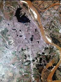
A part of Hanoi shot by satellite
- How will remote sensing satellite contribute to the development of the economy?
- Remote sensing technology helps us to ensure high and timely initiative in providing important data, meeting the needs of socio-economic development, security - defense . but not You can always buy or ask other countries.
Currently, according to incomplete calculations, funds for buying remote sensing images of economic sectors in our country every year need millions of dollars. Because there is not a single clue, strong people buy it. Even if this agency is available, other agencies do not know, still have to buy, so the exploitation and use are ineffective. In fact, there must be an agency to buy to know which one is available, which is not yet new to be expensive. Therefore, when launching satellite remote sensing and remote sensing image acquisition station, we will save a lot of money to spend every year.
?- Thank you Sir.
HAPPY done
- Vietnam will have a second remote sensing satellite
- Vietnam successfully processed satellite remote sensing images
- Simulation of the journey of Vietnam remote sensing satellite
- VNREDSAT-1 will be launched in the morning of May 7
- Vietnam's first remote sensing satellite is about to enter the universe
- Defer launch of VNREDSat-1 satellite because of rain
- Vietnam is about to have a second remote sensing satellite
- VNREDSat-1 satellite leaves the launch pad successfully
- Vietnam satellite image receiving station is ready
- Complete remote sensing system to monitor Hoang Sa and Truong Sa
- 2014: Vietnam will launch satellite remote sensing
- Belgium will produce VNREDSat-1B for Vietnam
 Vietnam 5th Asian champion on fuel-efficient vehicles
 Humorous Research Wins Ig Nobel Prize 2024
 Singer and songwriter Bob Dylan won the 2016 Nobel Prize for Literature
 We can read all NASA studies completely free of charge