Discover a map that changes the world
Drawed 500 years ago and quickly forgotten, a map shows people the most accurate picture of the world as well as the birth of America.
Nearly 500 years ago, in 1507, Martin Waldseemuller and Matthias Ringmann, two German scholars living in the mountains of the East of France, created a bold dance in the history of geography in particular and ideas. big in history in general. They declared a great surprise that the world not only included Asia, Africa and Europe, the three parts of the world known all along. The fourth part of the Earth was discovered by an Italian businessman named Amerigo Vespucci and to commemorate this event, Martin Waldseemuller and Matthias Ringmann decided to name America for the fourth continent in their map.
Drawn 15 years after Columbus first set foot on the Americas, with a width of 2.44 m and 1.35 m long, Waldseemuller map was introduced to the whole of Europe, giving a new and major perspective. the most accurate of the Earth compared to that era.
This map shows some of the first concepts that have appeared in history. In addition to naming the Americas, this is also the world's first 'portrait' plate with separate continental parts. This map also shows the existence of the sea that later explorer Ferdinand Magellan called the Pacific Ocean.
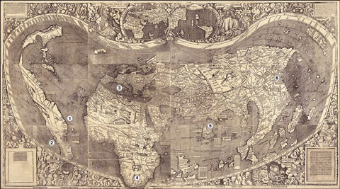
The first map accurately depicts parts of the world today.
The world has four parts
Waldseemuller map is one of the first documents to fully show the coastline of Africa. Most notably, this is the first map to 'see' the world with full 360 degrees of longitude. In short, it is the 'mother' of every modern map.
After 1507, copies of Waldseemuller maps began to be distributed at universities across Europe, displayed in classrooms and discussed by geographers and explorers. Gradually the recognition of the four-part Earth became more common.
Waldseemuller then said there were up to 1,000 copies of the printed map, a significant amount at that time. However, with the rapid development of geographic discoveries, the map was gradually replaced by new, more updated discoveries about the world and by 1570 it was completely deleted. Book off human memory.
Final copy
Fortunately, the last copy of this historical map still exists. Between 1515 and 1517, Johannes Schoner, a mathematician, bought a copy of the map, clamped it to a large-sized book and made it part of his massive library.
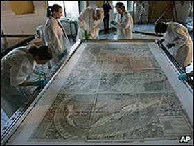
Library of Congress has spent $ 10 million to buy a map.
In the following years, Schoner studied the map carefully, but a few decades after newer maps appeared, with the shift to astronomy, he gradually forgot the Waldseemuller map. . The final version of the map was carefully stored in Schoner's book and was only discovered after 350 years.
Just like treasure-hunting stories, finding a map happens unexpectedly. In the summer of 1901, while doing research at the library of Wolfegg Castle, southern Germany, geography teacher Joseph Fischer found Schoner's book and quickly recognized the map he found. A few months later, his discovery became a world phenomenon with overwhelming press coverage.
The map was later included in Wolfegg Castle's collection until hundreds of years later, until 2003, when the Library of Congress announced that it would "return" the map from the castle owner for 10 million. USD. This is the highest price a library is paid to give away an item in its massive collection. Proudly, the American press mentioned the map as a US birth certificate.
Real value?
Despite being bought at such an amazing price, some observers believe this map is not worth it. However, now the map is displayed at a large library, studied by scholars and 'treasured' as an informational and rich historical document.
The map became a historical building, opening new knowledge about the world. Moreover, the first name of America appeared 500 years ago also made the world surprised. In addition to naming Amerigo Vespucci, the name America is also considered a play on words with different meanings such as 'newborn' or 'unknown land'.
The last copy of the Waldseemuller map not only shows Americans the origin of the continent's name and is a milestone to introduce the New World to Europe but also to make Copernicus think again about the cosmic order. .
- What will the world look like when there are only 100 people?
- Prepare to discover 'the lost world'
- Discover inside the world's largest condom factory
- Why is the 2010 World Cup ball difficult to kick?
- Discover the world's largest sperm bank
- Discover the scientific elements behind the 2018 World Cup ball
- Discover the world's
- Mysterious beauty invisible world
- Compare 7 world wonders in ancient and modern times
- Discover the world's longest-lived turtle
- 6 most terrifying landmarks in the world
- Discover the first tsunami skull in the world
 Discovered an ancient centipede fossil 99 million years old
 Discovered bat-like dinosaurs in China
 Discovered a 200-year-old bronze cannon of the coast
 Discover 305 million-year-old spider fossils