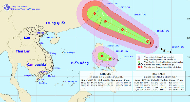
Latest information about Typhoon Talim and tropical depression on the South China Sea
At the same time both super typhoons and tropical depressions appear near the East Sea. Storm is strong level 14-15, jerk on level 17.
Typhoon Talim
At 19:00 on September 11 , the position of the center of TALIM was about 19.0 degrees North latitude; 133.8 degrees Kinh Dong. The strongest winds in the area near the center of the storm are strong at level 12 (115 to 135 km / hour), level 15.
It is forecasted that in the next 24 hours , the storm will move quickly in the West Northwest direction, about 30km per hour. By 19:00 on September 12, the location of the storm center was about 22.2 degrees Vi Bac; 127.3 degrees Kinh Dong, about 680km from Taiwan (China) to the East of Southeast. The strongest wind in the area near the center of the storm is strong 14-15 levels (150 to 185km / h), jerking on level 17.

Typhoon Talim and Tropical Depression.
In the next 24 to 48 hours , the storm moves in the West-Northwest direction, 20-25km per hour. By 19:00 on September 13, the position of the center of the storm was about 24.4 degrees Vi Bac; 122.9 degrees east longitude, about 100km east of Taiwan (China) to the southeast. The strongest wind is in the area near the center of strong storm level 15 (165 to 185 km / h), jerking over level 17.
In the next 48 to 72 hours, the storm moved in the northwest, 15km per hour.
Tropical depression near the East Sea
At 19:00 on September 11 , the position of the tropical depression center was about 14.6 degrees North latitude; 124.0 Kinh Dong, about 290km from the island of Lu-Dong (Philippines) to the Southeast. The strongest wind in the area near the center of strong tropical depression at level 7 (50 to 60 km / hour), level 9 shock.
It is forecasted that in the next 24 hours , tropical depressions will move west and northwest, about 10-15 km every hour. By 19:00 on September 12, the position of the tropical depression center was about 15.3 degrees Vi Bac; 121.9 degrees Kinh Dong, on the southeastern coast of Luong Dong (Philippines). The strongest wind in the area near the center of strong tropical depression at level 7 (50 to 60 km / hour), level 9 shock.
Due to the influence of the circulation in the west of the tropical depression, the eastern sea area between the East Sea has heavy rain and thunderstorms. In a thunderstorm there is the possibility of a tornado.
- Tropical depressions into the East Sea are likely to become strong storms
- Latest news about two tropical depressions consecutively in the South China Sea
- Tropical depression strengthened to No. 6, Nakri
- Why is the storm No. 6 constantly growing, moving unpredictably?
- Storm No. 13 weakens into a tropical depression
- Typhoon Toraji weakened into a tropical depression
- Storm No. 6 weakened, heavy rain in Thanh Hoa - Quang Nam
- Tropical depression on the South China Sea strengthened into a storm - storm Bebinca
- Matmo storm weakened into a tropical depression
- Super typhoon on level 17 is entering the South China Sea
- Tropical depressions landed on the East Sea
- Mangkhut super typhoon weakened into tropical depression on mainland China
 Is the magnetic North Pole shift dangerous to humanity?
 Washington legalizes the recycling of human bodies into fertilizer
 Lightning stone - the mysterious guest
 Stunned by the mysterious sunset, strange appearance