Latest Mars map
The US Geological Survey recently published the latest Mars map, which can provide important research information for future red planet exploration programs.
The map covers the entire surface of the red planet, combining various data and revealing some new information about Mars. Data were compiled from three NASA spacecraft and the European Space Agency's (ESA) Mars exploration program.
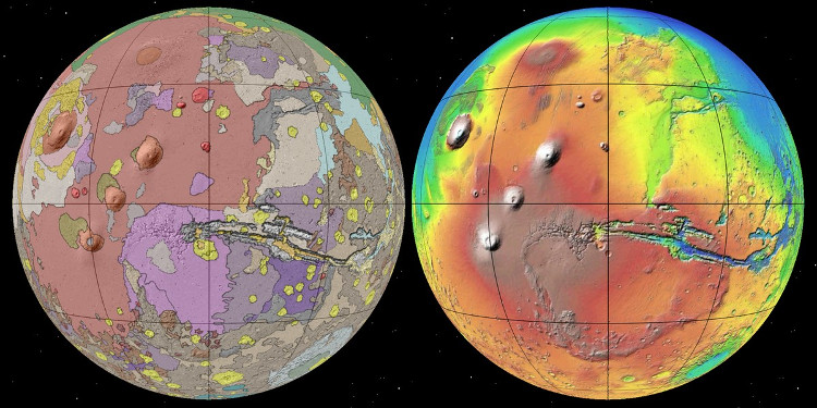
Geological map of Mars (left) and map showing elevation on the surface (right).(Photo: USGS)
According to NBC News, the map shows that Mars is "older" than the previous researchers' . The surface of this planet in the early period of the Noachis century , formed with an area three times larger than the previous map data.
The Noachis period is the oldest form of surface formation that still exists on Mars . During this period, the planet's surface is affected by many large collisions, extensive erosion and the presence of water.
The map that confirms the results of the study suggests that the red planet continues to have geological activity so far. Weather changes on the planet are related to the origin of surface water, groundwater near the surface and ice.
Scientists from the US Aeronautics Agency (NASA) drew the first Mars map in 1978, using data from the probe Mariner 9. After the red planet exploration missions, the research group Save each drawing many other maps.
- Latest photos of scenes never seen on Mars
- Overwhelmed with the latest images of Mars
- Close up of the amazing surface on Mars in NASA's latest series
- 'That' on Mars will be dangerous, but it can create new subspecies of humans
- What mystery of Mars awaits discovery?
- Unique photo
- Detect tremors: Flowers bloom on Mars?
- Latest information about Mars
- Mars really has life?
- Did the ocean on Mars get into the rock?
- Photo of the first 'footprint' on Mars
- NASA explains the confusing
 Van Allen's belt and evidence that the Apollo 11 mission to the Moon was myth
 The levels of civilization in the universe (Kardashev scale)
 Today Mars, the sun and the Earth are aligned
 The Amazon owner announced a secret plan to build a space base for thousands of people