Level 13 storm approaching the East Sea
In the afternoon of April 3, Typhoon Maysak is about 910 km from Luzon Island (Philippines) and the possibility of going to the East Sea.
Super Typhoon Maysak is able to enter the South China Sea
The central meteorological and hydrological forecasting center said that this afternoon, the storm center of Maysak is about 910 km east of Luzon Island (Philippines) to the southeast , the strongest wind is 149 km per hour (level 13). Storm mainly follows northwest direction with the speed of 20 km per hour.
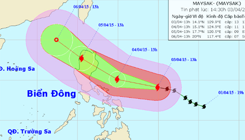
Predict the path of Typhoon Maysak.(Photo: nchmf.gov.)
By the afternoon, the storm center is about 360 km east of the island of Luzon (Philippines) to the southeast, the strong wind is 117 km per hour (level 10-11). Next, the storm followed the west northwest with an hourly speed of 20 km, on the afternoon of April 5, it was on the west coast of Luzon island.
Meteorological agency said, Maysak has the ability to enter the South China Sea and become the first storm this year.
According to the forecast of the Central Hydrometeorological Center, in 2015 there will be about 9-10 storms and tropical depressions operating on the East Sea, lower than the average for many years, but more than in 2014. About 4-5 storms will directly affect the mainland of Vietnam.
- Tin storm on the East Sea
- Tin storm on the East Sea (Storm No. 5) - Update
- Tin storm near the east sea
- Tin storm on the East Sea (Storm Nesat)
- Tin storm on the East Sea (Storm No. 5)
- Aere storm entered the South China Sea
- Typhoon Vincente hit China
- Prohibition of boats in the Gulf of Tonkin, coping with storm No. 3
- Aere storm jerks 10-12 levels into the South China Sea
- Tin latest No. 2 storm 9/7 and forecast for the next 10 days
- Bopha storm is active strongly near the South China Sea
- Emergency storm news (Storm No. 4) - updated
 Is the magnetic North Pole shift dangerous to humanity?
 Washington legalizes the recycling of human bodies into fertilizer
 Lightning stone - the mysterious guest
 Stunned by the mysterious sunset, strange appearance