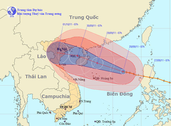
Tin storm on the East Sea (Storm No. 5)
At 07:00 on September 28, the location of the storm center is about 17.4 degrees Vi Bac; 116.8 degrees Kinh Dong, about 490 km from Hoang Sa archipelago to the East Northeast. The strongest winds in the area near the storm center are strong at level 12 (ie, from 118 to 133 km per hour), shocking level 13, level 14.
It is forecasted that in the next 24 hours, the storm will move west and northwest, about 20 km per hour. By 07:00 on September 29, the location of the center of the storm was about 18.9 degrees north latitude; 112.3 degrees east longitude, about 240km from Hoang Sa archipelago to the north. The strongest wind in the area near the storm center is strong at level 13 (ie from 134 to 149km an hour), level 14, level 15.

The path of the storm.(Click on the image to see the larger size)
In the next 24 to 48 hours, the storm moves mainly in the direction of the West-North West, about 15 to 20 km per hour. By 07:00 on September 30, the location of the storm center is about 20.2 degrees Vi Bac; 108.8 degrees Kinh Dong, about 270km from the coast of Quang Ninh - Thai Binh provinces to the East. The strongest wind in the area near the storm center is strong at level 12 (ie 118 to 133 km per hour), jerking level 13, level 14.
In the next 48 to 72 hours, the storm moved in the direction of West and West Northwest, about 15km per hour.
Due to the impact of storms, the North Sea (including the Paracel Islands) has strong winds of level 9, level 10, the area near the center of the storm passes through level 11, level 12, shock level 13, level 14. The sea was fierce. In addition, due to the influence of the southwest monsoon activity, in the middle and southern part of the South China Sea (including the Spratly waters), the waters from Binh Thuan to Ca Mau have strong winds of level 6. , level 7, level 8 shock and strong thunderstorms. Strong sea. In a thunderstorm, there should be a tornado.
The next newsletter was distributed at 11:30 on September 28.
News broadcast at: 09h30
- Tin storm on the East Sea (storm No. 7)
- Storm No. 12 weakens into a tropical depression
- Hurricane Kalmaegi moves at a very fast speed
- Tin storm on the East Sea: Typhoon Khanun
- Storm No. 15 has not melted, near the East Sea, a new storm appears
- Typhoon Kalmaegi directly affects the North
- Typhoon Kalmaegi has entered the South China Sea, the country has scattered rain
- Storm No. 10 leaves the East Sea, still heading towards Vietnam
- A new storm appeared on the east sea, storm Pakhar
- A strong storm of level 14 appeared in the South China Sea
- 19h tonight, the storm center is located on the waters of Quang Ninh - Hai Phong
- A new storm appeared near the East Sea
 Is the magnetic North Pole shift dangerous to humanity?
 Washington legalizes the recycling of human bodies into fertilizer
 Lightning stone - the mysterious guest
 Stunned by the mysterious sunset, strange appearance