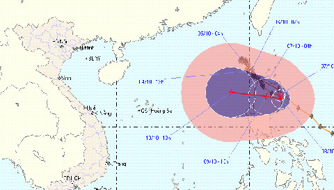
Storm No. 10 leaves the East Sea, still heading towards Vietnam
Hurricane No. 10 has crossed the meridian 120, out of Vietnam's East Sea territory, but the direction of the storm is still pointing towards Vietnam and can continue to return with stronger intensity.
Storm can return, stronger intensity
Mr. Vu Anh Tuan, Head of short-term meteorological forecasting department (Central Hydrometeorology Center) said: 'Storm No. 10 is still under the influence of super storm Melor so the direction and development is still complicated. trash '.

Storm No. 10 is raging on Lu island (Philippines). Despite being out of place
but our country still faces the direction of moving to Vietnam and may be stronger
(Photo: NCHMF)
According to Tuan, at the present time, there are 3 possible possibilities: Or super typhoon Melor brings storm No. 10 away from the Pacific Ocean (this possibility accounts for about 20%); or No. 10 typhoon continues to move around the Philippine island of Luang Prabang, then weakens (this ability accounts for about 30%).
The third possibility is expected to occur more (about 50%) that the No. 10 hurricane continues to struggle in the current area and then strengthens, continuing to move into the South China Sea territory. .
' This is a forecast, so we choose the worst ability to warn, take precautions and be alert for sea activities. All developments of hurricane number 10 may change due to dependence on super typhoon Melor , 'Tuan said.
About the current location of the storm: At 13 hours on October 7, the location of the storm center number 10 is about 17.4 degrees Vi Bac; 122.3 degrees Kinh Dong, on the east side of Lu - Dong (Philippines). The strongest winds in the area near the storm center are strong at level 8 (ie 62 to 74 km per hour), level 9 and level 10 jerks.
It is forecasted that in the next 2 to 3 days, the storm No. 10 moves in the direction of West and West Northwest, about 10 - 15 km per hour.
By 13 o'clock on October 10, the location of the storm center is about 17.6 degrees North latitude, 118.6 degrees east longitude, 690 kilometers east of Hoang Sa archipelago to the Northeast.
The strongest wind in the area near the storm center is strong at level 8 (ie 62 to 74 km per hour), level 9, level 10. From the center of the storm, dangerous winds from level 6 and above have a radius of about 200 km .
Due to the impact of storms, the East Sea in the North East Sea has strong winds of level 6, level 7, shock level 8, level 9. Strong sea.
Flash floods in Binh Thuan left 3 people dead and missing
Due to the upstream rain in the Luy river basin, 5 communes in Bac Binh district (Binh Thuan province) have suffered a flash flood, causing 1 death and 2 missing people.
In addition, flash floods also caused 127 houses in these 5 communes to collapse, roof and swept away; more than 1,000 hectares of crops are flooded and damaged.
Regarding the work of overcoming the consequences of typhoon No. 9 in the Central and Central Highlands provinces, the report of the Central Steering Committee for Flood and Storm Control showed that Kon Tum is the most concentrated point of rescue.
On October 6, the 3rd Corps Command used 150 cadres and soldiers and 1 tractor truck, 1 self-propelled ferry, 3 cars, helping Kon Tum people overcome the consequences of the storm No. 9. out.
- Tropical depression strengthened into storm No. 2, heading to Quang Ninh - Hai Phong
- 2 super typhoons followed each other into the South China Sea
- Storm No. 7 increases 2 levels when entering the East Sea
- Typhoon Haiyan is heading into Quang Ngai
- Tropical depressions are likely to become strong storms heading into the South China Sea
- Hurricane Melor jerked level 17 is heading into the East Sea
- Typhoon Sarika accelerated, heading straight to Nam Dinh, Quang Ninh
- The storm with extraordinary speed is heading into the South China Sea
- Kai-Tak storm surged, heading to Cao Bang - Lang Son
- Tin storm on the East Sea (storm No. 7)
- Storm No. 12 weakens into a tropical depression
- The South China Sea has big storms and tornadoes threatening the waters of Vietnam
 Is the magnetic North Pole shift dangerous to humanity?
 Washington legalizes the recycling of human bodies into fertilizer
 Lightning stone - the mysterious guest
 Stunned by the mysterious sunset, strange appearance