Tropical depressions are likely to become strong storms heading into the South China Sea
According to the Central Center for Hydrometeorological Forecasting, currently (September 6), a tropical depression operating near the island of Luang Prabang is likely to become a storm and is heading into the South China Sea.
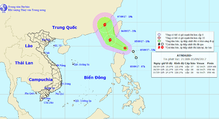
In 19h on September 5, the position of tropical depression was about 19.6 degrees North latitude; 122.5 degrees east longitude, about 190km from Luzon Island (Philippines) to the North East North. The strongest wind in the area near the strong tropical depression center level 6-7 (40-60 km / hour), level 9 shock.

Location and direction of tropical depression.(Photo: NCHMF).
It is forecasted that in the next 24 hours , tropical depressions will move in the northwest direction, about 15 km per hour and can be strengthened into storms.
At 19h on September 6, the location of the center of the storm was about 21.3 degrees Vi Bac; 119.4 degrees Kinh Dong, about 350km from Fujian Province (China) to the Southeast. The strongest wind in the area near the center of strong storm level 8 (60-75 km / hour), level 10 jerk.
Due to the influence of tropical pressure, it is possible to become strong storm, from noon (September 6), the North East Sea in the North Sea East gradually increases to level 6-7, the area near the center of storm passes through level 8 , level 10 jerky; strong sea.
In the next 24 hours , the area is dangerous (strong wind from level 6 or higher): north of latitude 20.0 degrees North latitude; east of meridian 118.0 degrees Kinh Dong. Disaster risk level: level 3.
For the next 24 to 48 hours , the storm will move in the North-West direction, about 15km per hour.
- Tropical depressions enter the South China Sea, potentially strong into storms
- Tropical depressions may intensify into storms when approaching the Spratlys
- Occurrence of tropical depression near the South China Sea, the possibility of strong storms
- Tropical depressions are likely to become strong storms towards the North
- Tropical depressions can enter the East Sea in the next 2 days
- Vietnam must receive 6-7 storms and tropical depressions
- Tropical depressions into the East Sea are likely to become strong storms
- Tropical depressions are gradually stronger in the South China Sea
- Storms and tropical depressions will appear continuously this year
- Hurricane Podul, level 10, is heading into the South China Sea
- Tropical depressions approach the South China Sea, potentially increasing into storms
- Latest news about tropical depression
 Is the magnetic North Pole shift dangerous to humanity?
 Washington legalizes the recycling of human bodies into fertilizer
 Lightning stone - the mysterious guest
 Stunned by the mysterious sunset, strange appearance