Occurrence of tropical depression near the South China Sea, the possibility of strong storms
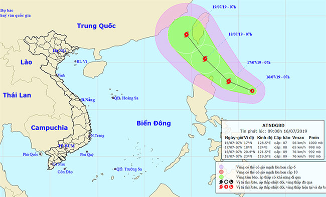
According to the National Center for Meteorological and Hydrological Forecasting, at 7:00 am July 16, the tropical depression center is about 440 kilometers east of Luzon Island. The strongest wind in the area near strong tropical depression center level 6-7 (40-60km / h), level 9 shock.
It is forecasted that in the next 24 hours , tropical depressions will move in the west-northwest direction, each hour will be 10-15 km and likely to increase into storms.
At 7:00 on July 17 , the storm center was about 200 km east of northern Luzon Island to the East. The strongest wind in the area near the center of strong storm level 8 (60-75km / h), level 10 jerks.

Diagram of forecasting the direction of tropical depressions - (Photo: National Meteorological Forecast Center).
In the next 24-48 hours , the storm moves in the North-West direction, about 15km per hour and there is also a strong possibility.
At 7:00 on July 18 , the storm center was about 220 km north of Luzon Island. The strongest wind in the area near the center of the storm is strong at level 8-9 (60-90km / h), level 11 jerks.
In the next 48-72 hours , the storm moves in the north-northwest direction, about 15km per hour. By 7:00 pm on July 19, the storm center right on the southwest coast of Taiwan island. The strongest wind in the area near the center of the storm is strong at level 8-9 (60-90km / h), level 11 jerks.
Also according to the National Center for Meteorological and Hydrological Forecasting, due to the strong influence of the southwest monsoon, during the day and tonight, July 16, on the waters from Binh Thuan to Kien Giang, the Gulf of Thailand and the area In the middle and southern part of the South China Sea (including the Spratly Islands), there are showers and thunderstorms. In the thunderstorm there was the possibility of tornado and strong wind.
The sea area from Binh Thuan to Ca Mau and the South China Sea area (including Truong Sa archipelago) has strong Southwest wind at level 5, sometimes level 6, level 8 shock. High sea waves 2.0-4.0m. The sea is rough.
- Tropical depressions move quickly at sea, with the possibility of strong storms
- Tropical depressions into the East Sea are likely to become strong storms
- Tropical depressions may intensify into storms when approaching the Spratlys
- Tropical depressions approach the South China Sea, potentially increasing into storms
- Tropical depressions are likely to become strong storms heading into the South China Sea
- Tropical depressions enter the South China Sea, potentially strong into storms
- Hurricane Pakhar and tropical depression are
- Stormy season, tropical low pressure will come soon in the South China Sea
- Why is the storm No. 6 constantly growing, moving unpredictably?
- Appears tropical depression on the East Sea
- Latest information about Typhoon Talim and tropical depression on the South China Sea
- Strong tropical depression into storm No. 1, approaching the Vietnamese mainland
 Is the magnetic North Pole shift dangerous to humanity?
 Washington legalizes the recycling of human bodies into fertilizer
 Lightning stone - the mysterious guest
 Stunned by the mysterious sunset, strange appearance