Tropical depressions may intensify into storms when approaching the Spratlys
Last night (January 2), the tropical depression crossed the Central Island of Palawan (Philippines) and entered the South China Sea.
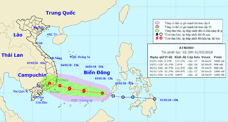
At 01:00 on January 3, the position of the tropical depression center is about 9.9 degrees north latitude; 117.2 degrees Kinh Dong, about 360km from Song Tu Tay island (belonging to Truong Sa archipelago) to the southeast. The strongest wind in the area near the strong center of tropical low pressure level 7 (50-60km / hour), level 9 shock.

The path of the tropical depression.
It is forecasted that in the next 12 hours , the tropical low pressure will move quickly in the direction of West-Northwest, each hour can travel 25-30km and is likely to become strong. By 13:00 on January 3, the location of the storm center is about 10.3 degrees Vi Bac; 114.0 degrees Kinh Dong, about 140 km from Song Tu Tay Island (belonging to Truong Sa archipelago) to the south. The strongest wind is in the area near the center of strong storm level 8 (60-75km / hour), level 10 shock.
In the next 12 to 24 hours , the storm moved west-northwest, about 20km per hour. By 01:00 on January 4, the location of the storm center is about 10.7 degrees Vi Bac; 111.5 Kinh Dong, about 280km from Phu Quy island to the East. The strongest wind is in the area near the center of strong storm level 8 (60-75km / hour), level 10 shock.
Dangerous zone in the South China Sea in the next 24 hours (strong wind level 6 or higher) from latitude 8.0 to 12.0 degrees North latitude; east of the meridian 110.0 degrees Kinh Dong. Disaster risk level: level 3.
In the next 24 to 48 hours , the storm moved mainly in the direction of West-Northwest, about 15km per hour.
- New storm entered the Philippines again when Melor just melted
- Tropical depressions are likely to become strong storms towards the North
- Correct understanding of storms and tropical depressions
- Latest news about tropical depression
- Occurrence of tropical depressions in the East Sea is likely to increase to a storm
- News of nearshore tropical depressions and tropical depressions near the East Sea
- Tropical depressions enter the South China Sea, potentially strong into storms
- Vietnam must receive 6-7 storms and tropical depressions
- Occurrence of tropical depression near the South China Sea, the possibility of strong storms
- Storms and tropical depressions will appear continuously this year
- Tropical depressions are likely to become strong storms, Bac Bo heavy rain
- Tropical depressions into the East Sea are likely to become strong storms
 Is the magnetic North Pole shift dangerous to humanity?
 Washington legalizes the recycling of human bodies into fertilizer
 Lightning stone - the mysterious guest
 Stunned by the mysterious sunset, strange appearance