Latest news about tropical depression
Tropical depressions in the Gulf of Tonkin have weakened and faded away. Meanwhile, tropical depressions formed in the North China Sea are still moving and are likely to increase into storms.
According to the Central Center for Meteorological and Hydrological Forecasting, last night (August 16), the tropical depression on the northern part of the Gulf of Tonkin weakened into a low pressure area, then the low pressure area continued to move. east, go to the northwest of Leizhou Peninsula (China) and fade away.
Today (August 17), in the Gulf of Tonkin and the northern coastal area continue to have thunderstorms and strong winds of level 7-8.
For tropical depressions formed in the north of the East Sea, at 4 am this morning (August 17), the position of tropical depressions is located on the southern coastal region of Guangdong Province (China). The strongest wind is in the area near the strong tropical depression at level 6-7 (40-60km / hour), level 9-10.
Forecast for 24 hours I , tropical depressions move in the West-South-West direction, about 10km per hour and can increase to storm.
By 4 o'clock tomorrow morning (August 18) , the location of the storm center is about 100km to the east of Lei Chau Peninsula (China). The strongest wind is in the area near the center of strong storm level 8 (60-75km / hour), level 10-11.
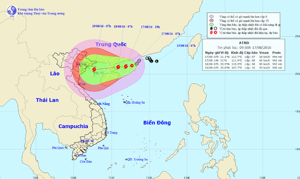
The position and direction of tropical depression in the South China Sea.(Photo of Center for Hydrometeorology Forecast).
Due to the influence of the circulation of tropical depressions later intensifying into storms, the North Sea in the East Sea has strong winds of level 6-7, level 8-9. The area of the Gulf of Tonkin and the northern coastal area continues to have strong rain and wind.
From August 17 to August 20, there was a large-scale heavy rain in the North and North Central region. The risk of flash floods, landslides in high mountainous areas, flooding in low-lying areas.
In order to proactively deal with the flooding situation, Minister of Agriculture and Rural Development Nguyen Xuan Cuong - Head of the Central Steering Committee for Disaster Prevention and Rescue Search continues to work on electricity, asking localities to respond to these problems. Bad situation due to weather.
Accordingly, localities from Quang Ninh - Ha Tinh need to closely monitor the evolution of tropical depression / storm. Calling ships and boats to operate in the Gulf of Tonkin area for safe shelter. Strictly control tourism activities on the island, especially in Quang Ninh and Hai Phong.
The mountainous, midland and northern central provinces regularly monitor and inform the flooding situation to the authorities and people, especially in remote areas.
Organize to inspect areas at risk of flash floods; reviewing dams, operating valve gates to discharge water to ensure flood safety for downstream areas of reservoirs.
The Central Steering Committee for Natural Disaster Prevention and Rescue seeks to rescue provinces and cities to prepare forces and rescue and rescue facilities in time to respond to a bad situation.
- Storm No. 1 weakened into tropical depression, the North continued to have small rain
- Latest news about two tropical depressions consecutively in the South China Sea
- Tropical depression Kajiki weakened in the East Sea
- News of tropical low pressure near shore
- Tropical depressions move quickly at sea, with the possibility of strong storms
- Storm No. 13 weakens into a tropical depression
- Tropical depressions landed on the East Sea
- News of tropical depression near the East Sea
- Latest information about Typhoon Talim and tropical depression on the South China Sea
- Tropical depression at level 8 formed in the South China Sea
- Appears tropical depression near the East Sea
- Tropical depression intensified into storm No. 3
 Is the magnetic North Pole shift dangerous to humanity?
 Washington legalizes the recycling of human bodies into fertilizer
 Lightning stone - the mysterious guest
 Stunned by the mysterious sunset, strange appearance