News of tropical low pressure near shore
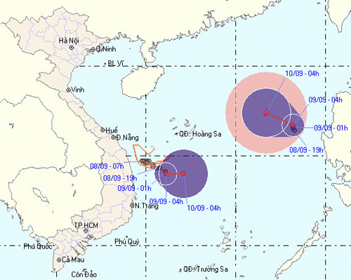
At 4 o'clock on September 9, the position of the tropical depression center was about 14.0 degrees north latitude; 111.1 degrees Kinh Dong, about 200 km from the coast of Quang Ngai - Binh Dinh provinces to the East. The strongest wind in the area near the center of strong tropical depression at level 6 (ie from 39 to 49 km per hour), jerk level 7.
It is forecasted that in the next 24 hours, the low pressure will move slowly in the direction between East and Southeast, about 5 km per hour, and weaken into a low pressure area. At 04:00 on September 10, the central position of the low pressure area is about 14.0 degrees north latitude; 112.1 degrees east longitude. The strongest wind in the center of the low pressure area falls below level 6 (ie less than 39 km per hour).

The path and location of the storm (Photo: nchmf.gov.vn)
Meanwhile, at 04:00 on 9/9, the tropical depression in the North East Sea is located at about 16.7 degrees North latitude, 118.2 degrees Kinh Dong, 700km from Hoang Sa archipelago. eastward. The strongest wind in the area near the strong center of tropical low pressure level 6, level 7 (from 39 to 61 km per hour), level 8, level 9. Forecast in the next 24 hours, tropical depressions move In the Northwest direction, every hour is about 5-10 km, and it is likely to become a storm. At 04:00 on September 10, the location of the storm center is about 17.4 degrees north latitude, 116.7 degrees east longitude. The strongest winds in the area near the storm center are strong at level 8 (ie 62 to 74 km per hour), level 9 and level 10 jerks.
Due to the influence of near-shore low pressure, the waters of the provinces from Quang Ngai to Binh Dinh and the southwest of Hoang Sa archipelago have strong winds of level 6, shocking level 7. The sea is rough. The provinces from Quang Tri to Binh Dinh have moderate rain, heavy rain, and a place with very heavy rain. The North East Sea has strong whirlwinds at level 6, level 7, then increases to level 8, level 9, level 10. The sea is very strong.
In addition, due to the combined effects with strong southwest monsoon winds, in the Middle and South East Sea, the waters from Binh Thuan to Ca Mau have strong winds of level 6, level 7, level 8, level 9. Sea strong dynamics. In the provinces of the Central Highlands and the South, there is rain and moderate rain, where there is heavy rain and thunderstorms.
The next newsletter was broadcast at 9:30 on 9/9

News broadcast at: 5:30
- This afternoon, the new low pressure is close to South Central and South
- Tropical depressions intensified into storm No. 10
- News of nearshore tropical depressions and tropical depressions near the East Sea
- Hurricane 4 has just weakened and appeared a tropical depression heading into the East Sea
- A new low pressure appears, potentially strengthening into a storm
- Tropical depression towards the East Sea
- Tin storm near the shore: Storm No. 3 appeared, heading to Da Nang - Quang Ngai
- Latest news on tropical depressions in the East Sea
- Appearing low pressure area in the South China Sea
- Appearing low pressure area on the East Sea, can be directed towards Vietnam
- Hurricane Pakhar and tropical depression are
- Storm has not arrived, Danang has suffered
 Is the magnetic North Pole shift dangerous to humanity?
 Washington legalizes the recycling of human bodies into fertilizer
 Lightning stone - the mysterious guest
 Stunned by the mysterious sunset, strange appearance