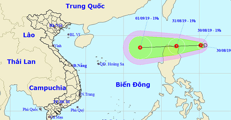
Hurricane 4 has just weakened and appeared a tropical depression heading into the East Sea
According to the National Center for Hydrometeorological Forecasting, a tropical depression about 350km to the east of Luzon Island (Philippines) is heading to the East Sea and is likely to become stronger.
At 19:00 on August 30 , the location of the tropical depression was about 18.7 degrees North latitude; 125.2 degrees Kinh Dong, about 330km to the east of Luang Prabang (Philippines). The strongest wind near the center of strong tropical depression is level 6 (40-50km / h), level 8.

Direction of tropical depressions.
It is forecasted that in the next 24 hours , tropical depressions will move mainly to the West, traveling about 10-15km per hour and possibly stronger. By 19:00 on August 31, the location of the tropical depression was about 18.6 degrees North; 122.0 degrees Kinh Dong, in the northeastern part of Luang Prabang Island The strongest wind near the center of strong tropical depression is level 6-7 (40-60km / h), level 9.
Over the next 24 to 48 hours , the tropical depression moves westward, traveling about 20km every hour, into the South China Sea and continues to strengthen. Until 19:00 on September 1, the location of tropical depression at about 18.4 degrees North latitude; 117.2 degrees Kinh Dong, about 530km from the Paracel Islands to the Northeast. The strongest wind near the center of strong tropical depression is level 7 (50-60km / h), level 9.
Dangerous region in the East Sea in the next 24 to 48 hours: East meridian 115.0 degrees East longitude; north of parallel 16.0 degrees North latitude. Disaster risk level: level 3.
- Washi weakened into a tropical depression
- Tropical depression Kajiki weakened in the East Sea
- Storm No. 14 weakens into a tropical depression
- Typhoon Tembin weakened into a tropical depression
- Storm No. 13 weakens into a tropical depression
- Banyan storm weakened and suddenly
- Storm No. 1 weakened into tropical depression, the North continued to have small rain
- A strong hurricane number 10 with level 12 approaches the land
- Tropical depressions landed on the East Sea
- Tropical depressions are likely to become strong storms heading into the South China Sea
- Tropical depression towards the East Sea
- The first storm appeared in the South China Sea
 Is the magnetic North Pole shift dangerous to humanity?
 Washington legalizes the recycling of human bodies into fertilizer
 Lightning stone - the mysterious guest
 Stunned by the mysterious sunset, strange appearance
 After El Nino, it's La Nina again: 13 storms predicted in the East Sea, all at the end of the year?
  Climate change can reduce the frequency of storms and tropical cyclones
  Tropical forests are losing their ability to absorb carbon
  Tropical depressions move quickly at sea, with the possibility of strong storms
  Tropical depression Kajiki weakened in the East Sea
  3 depressions pressed on the sea, the Central faced unusual wind and rain