3 depressions pressed on the sea, the Central faced unusual wind and rain
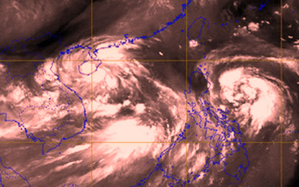
While the old tropical depression was likely to become a typhoon No. 5, another region became stronger as a tropical depression. At the same time, another low pressure area was about to become a storm off the coast of the Philippines, all three interacting with each other to cause unusual wind and rain.
Why is there such an unusual weather?
Weather forecasting expert Le Thi Xuan Lan said that there is currently a tropical convergence strip stretching from mainland Asia to the Pacific Ocean. This is a factor that forms weather types such as tropical depressions and storms.

The East Sea extends to the Pacific Ocean where there are many tropical depressions and storms - (Photo: IPS MeteoStar).
On the other hand, the sea temperature is relatively warm at the moment , high humidity creates favorable conditions for the strong pressure to become tropical depression, storm.
Regarding the two tropical depressions operating in the South China Sea, Lan said that the newly formed low pressure area in the morning of September 2 was the tail margin of the old tropical depression in operation.
Ms. Lan added that there are many models forecasts about the evolution of these tropical depressions, but they will mainly evolve in two directions.
- Firstly , the old tropical depression will move to the sea area near Con Co island (Quang Tri) and then back out due to the storm that is about to form off the coast of the Philippines.
- Second , the emergence of a new tropical depression will help the old tropical depression escape the suction of a typhoon about to form off the coast of the Philippines and reach the mainland. According to this forecast model, tropical low pressure will not be strong as a storm or only a weak storm, but it will cause a huge flood for the Central of our country.
After the old tropical low pressure on the shore and weakened into a low region, this low area will merge into the new tropical low pressure formed in the morning of September 2, helping this tropical depression become stronger into a storm and about to be formed by the storm offshore Philippineshines pulled back.
Regarding the situation of rain and wind, Ms. Lan said that the rain and wind will last until 5, 6/9, and then it will decrease. Due to the impact of previous rain and wind, localities need to prevent dangerous floods.

Two tropical depressions in the South China Sea and the low pressure area are about to become storms off the Philippine coast - (Photo: thoitietvietnam.com).
"In our country, the damage often happens after typhoons due to people relying on it, this needs to be very cautious and alert , " Lan warned.
The Northern region will receive rain and wind in the coming time due to the tropical convergence band.
Also according to Ms. Lan, the Pacific region is at the peak of storms and storms, the formation of many tropical depressions, storms at one time is not strange. Unusual here is the interaction of the tropical depression, this storm will create abnormal movement direction.
People on land and seafarers should regularly monitor forecasts for precautions.
- South Central will have heavy rain due to tropical depressions
- Tropical depressions in the East Sea cause rain in the Central and South Vietnam
- Tropical depressions continue to appear on the East Sea
- Central Vietnam will have heavy thunderstorms, wind gusts to level 9
- Unusual rain in the South
- Add cold air causing very heavy rain from Nghe An to Quang Nam
- Cold air causes dangerous rain and thunderstorms in the North and Central
- Vietnam must receive 6-7 storms and tropical depressions
- Tropical depressions are likely to become strong storms, Bac Bo heavy rain
- Central Vietnam faces flood again
- Storms and tropical depressions will appear continuously this year
- Tropical depressions may intensify into storms when approaching the Spratlys
 Is the magnetic North Pole shift dangerous to humanity?
 Washington legalizes the recycling of human bodies into fertilizer
 Lightning stone - the mysterious guest
 Stunned by the mysterious sunset, strange appearance
 After El Nino, it's La Nina again: 13 storms predicted in the East Sea, all at the end of the year?
  Climate change can reduce the frequency of storms and tropical cyclones
  Tropical forests are losing their ability to absorb carbon
  Tropical depressions move quickly at sea, with the possibility of strong storms
  Tropical depression Kajiki weakened in the East Sea
  Latest news about two tropical depressions consecutively in the South China Sea