Tropical depressions continue to appear on the East Sea
The Central Center for Meteorological and Hydrological Forecasting in the afternoon of October 11 said that, currently, a tropical depression operates on the eastern Philippines.

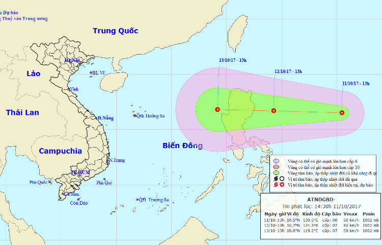
The path of the tropical depression.
At 13h , the position of the tropical depression center is about 16.5 degrees North latitude; 130.5 degrees east longitude. The strongest wind in the area near the strong tropical depression center level 6-7 (40-60km / h), level 9 shock.
It is forecasted that in the next 24 hours , the tropical low pressure will move quickly in the West, about 25-30km per hour.
By 13:00 on October 12 , the position of tropical depressions is about 240km from Ludong Island (Philippines) to the East.
The strongest wind in the area near the strong tropical depression center level 6-7 (40-60km / h), level 9 shock.
It is forecasted that in the next 24 to 48 hours, tropical depressions will move in the west, about 20-25km every hour and have a stronger ability
- News of nearshore tropical depressions and tropical depressions near the East Sea
- Occurrence of tropical depressions in the East Sea is likely to increase to a storm
- Latest news on tropical depressions in the East Sea
- Tropical depressions on the East Sea are strengthening
- Latest news about tropical depression
- Tropical depressions level 9 near the East Sea
- Tropical depressions change direction, moving north
- Occurrence of tropical depressions in the East Sea, rainstorms all over the country
- Occurrence of tropical depression near the South China Sea, the possibility of strong storms
- Appears tropical depression on the East Sea
- Tropical depressions move quickly to the East Sea and the cold north
- Occurring tropical depression on the East Sea, Hanoi has heavy rain tonight
 Is the magnetic North Pole shift dangerous to humanity?
 Washington legalizes the recycling of human bodies into fertilizer
 Lightning stone - the mysterious guest
 Stunned by the mysterious sunset, strange appearance