On the afternoon of November 3, the low pressure area in the sea area off the South Central Coast provinces, from Binh Dinh-Ninh Thuan, strengthened into a tropical depression.
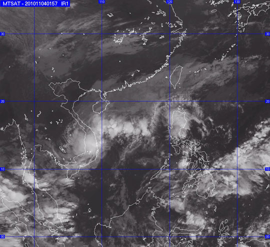
Photos taken from satellites. (Source: nchmf.gov.vn)
At 16 o'clock, the position of the tropical depression center was in the range of 11.5 to 12.5 degrees North; 110.5 to 111.5 degrees Kinh Dong, 180km from the coast of Phu Yen-Ninh Thuan to the East. The strongest wind in the area near the center of strong tropical depression at level 6 (ie from 39 to 49 km per hour), level 7, level 8.
It is forecasted that in the next 24 hours, tropical depressions will hardly move or move slowly in the direction between West and West Southwest, about 5km per hour.
By 16:00 on November 4, the position of the tropical depression center was in the range of 11.0 to 12.0 degrees North latitude; 109.5 to 110.5 degrees Kinh Dong, on the waters of Phu Yen-Binh Thuan provinces. The strongest wind in the area near the center of strong tropical depression at level 6 (ie from 39 to 49km / hour), level 7, level 8.
Due to the impact of tropical depressions combined with strong and turbulent northeast wind zones in the high east wind zone, the North and the Middle East (including the Paracel Islands) and the outer sea. offshore the provinces from Quang Tri to Ninh Thuan with strong winds of level 7, sometimes level 8, level 9-10 shock and strong thunderstorms. The sea is very strong. In a thunderstorm, it is necessary to prevent a tornado and a strong wind.
In the provinces from Thua Thien Hue to Khanh Hoa, there is moderate rain, heavy rain.
 Is the magnetic North Pole shift dangerous to humanity?
 Washington legalizes the recycling of human bodies into fertilizer
 Lightning stone - the mysterious guest
 Stunned by the mysterious sunset, strange appearance