Tropical depression towards the East Sea
While Typhoon Haiyan is causing heavy rain and high winds in Quang Ninh, Hai Phong, in the East Sea, a tropical depression appears, the possibility of strengthening into a storm.
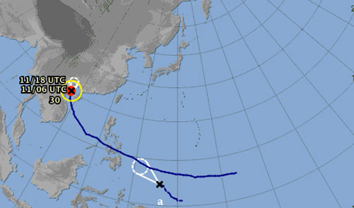
A low pressure area is forming.(Photo: .jma.go.jp)
According to the forecast of the Japan Meteorological Station, the new low pressure is formed in the southeastern Philippines and goes towards the East Sea at a speed of about 25km an hour.
On November 6, at the meetings of the Central Steering Committee for Flood and Storm Control on Storm No. 13, Mr. Bui Minh Tang, director of the Central Center for Meteorological and Hydrological Forecasting, said that this low pressure area can enter the East Sea on 13-14 November and the possibility of becoming the number 15 storm of the year.
However, the distance of the lower depression is still about 1,500km away from southern Philippines and predicts its path is still complicated.
- Tropical depressions landed on the East Sea
- Tropical depression Kajiki weakened in the East Sea
- Appears tropical depression near the East Sea
- Appears tropical depression on the East Sea
- Hurricane 4 has just weakened and appeared a tropical depression heading into the East Sea
- Tropical depressions cause heavy rain and thunderstorms
- Depressing tropical depression in the East Sea
- Tropical depressions move quickly at sea, with the possibility of strong storms
- Storm No. 13 weakens into a tropical depression
- Occurrence of tropical depression near the South China Sea, the possibility of strong storms
- Tropical depression on the East Sea
- Reappeared tropical depression, likely to intensify into a typhoon
 Is the magnetic North Pole shift dangerous to humanity?
 Washington legalizes the recycling of human bodies into fertilizer
 Lightning stone - the mysterious guest
 Stunned by the mysterious sunset, strange appearance