At 13:00 on November 5, the location of the tropical depression was about 13.8 degrees North latitude; 115.1 degrees Kinh Dong, about 270km to the north of Song Tu Tay Island (Spratly Islands). The strongest wind near the center of strong tropical low pressure level 7 (50-60km / h), level 9. The radius of strong wind level 6, level 8 or higher is about 70km from the center of tropical low pressure.
It is forecasted that in the next 24 hours , tropical depressions will move slowly to the East, each hour will be about 5km and likely to become typhoons.
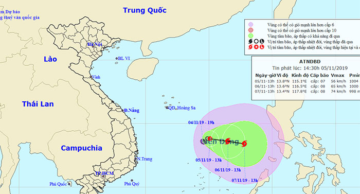
Location and direction of tropical depressions.
By 13:00 on November 6 , the location of the storm center was about 13.6 degrees Vi Bac; 116.5 degrees Kinh Dong, about 350km northeast of Song Tu Tay Island (Spratly Islands). The strongest wind near the center of strong storms level 8 (60-75km / h), level 10.
Dangerous areas in the South China Sea in the next 24 hours (strong winds of grade 6, level 8 or higher): North of the North latitude 11.5 degrees North.
Over the next 24 to 48 hours , the typhoon continued to move eastward, traveling about 5km every hour and potentially gaining strength. By 13:00 on November 7, the location of the storm center was about 13.4 degrees Vi Bac; 117.8 degrees Kinh Dong. The strongest wind near the center of strong storms level 8-9 (60-90km / h), level 11.
Over the next 48 to 72 hours, the storm hardly moved and continued to intensify.
Disaster risk level: level 3.
Due to the influence of tropical depression combined with cold air, in the area between the South China Sea (including the North Sea area of the Spratly Islands), the North China Sea (including the Paracel Islands) has showers and thunderstorms, strong winds levels 6-7, level 8-9; rough sea. The South China Sea area has showers and thunderstorms with tornadoes and strong winds. Ocean waves from 2-4m high; rough sea.