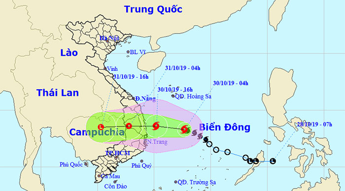
Tropical depression strengthened into a typhoon No. 5, heading to Binh Dinh - Phu Yen
In the evening of October 29, the tropical depression became a 5th storm (known internationally as Matmo) in the East Sea with a maximum wind of 75 km / h (grade 8), directed to the provinces of Binh Dinh - Phu Yen .
At 04:00 on October 30 , the center of the storm was about 13.3 degrees Vi Bac; 112.7 degrees Kinh Dong, in the Northwest of Spratly Islands, about 350km to the East of Binh Dinh-Ninh Thuan provinces to the East. The strongest wind near the center of strong storms level 8 (60-75km / h), level 10. Strong wind radius from level 6, shock from level 8 or more about 110km from the center of the storm.
It is forecasted that in the next 12 hours , the storm will move to the Northwestern direction, each hour will be 15-20km and likely to be stronger. By 16:00 on October 30, the center of the storm was about 13.6 degrees North; 110.2 degrees Kinh Dong, in the waters of Quang Ngai-Ninh Thuan provinces. The strongest wind near the center of strong storms level 9 (75-90km / h), level 11.

Location and movement of storm No. 5.
It is forecasted that in the next 12 to 24 hours , the typhoon will move mainly to the West, travel 15-20km every hour, go to mainland provinces from Quang Ngai to Khanh Hoa and gradually weaken into a tropical depression. By 04:00 on October 31, the central location of the tropical depression was about 13.6 degrees North latitude; 107.8 degrees Kinh Dong, on the mainland provinces of the Central Highlands. The strongest wind near the center of strong tropical depression is level 6 (40-50km / h), level 8.
Dangerous areas in the East Sea in the next 24 hours (strong winds from level 6, jerking from level 8 or higher): North of latitude 10.5 degrees North.
Over the next 24 to 36 hours, the tropical depression moved westward, inland and weakened into a low pressure area in Cambodia.
Disaster risk level: level 3.
2. High winds in the Sea
Due to the influence of the storm, in the North and between the East Sea and the northwestern area of the Spratly Islands, there is a strong wind of 6-7, the area near the center of the storm passes through level 8, then increases to level 9, level 11 ; The sea is very strong.
In the offshore waters of provinces from Quang Ngai to Ninh Thuan (including Ly Son island district), the wind gradually rises to level 7, the area near the center of the storm passes through level 8-9, level 11, high waves 3- 5m, area near the center of storm 4-7m; the sea is very strong; in the South of Tonkin Gulf and the sea area from Quang Tri to Quang Nam, there is a strong northeast wind of grade 6 and level 8; rough sea.
3. Strong winds on land
From noon and this afternoon (October 30), on the mainland of Quang Nam and Ninh Thuan provinces, the wind is strong to level 6-7, level 9; Quang Ngai, Binh Dinh, Phu Yen and Khanh Hoa provinces have strong winds of grade 6-7, later increase to grades 7-8 and level 10.
4. Very heavy rain in Central and Central Highlands
During October 2 - October 31, provinces / cities from Thua Thien Hue to Ninh Thuan and the Central Highlands region have very heavy rainfall (Total rainfall of 300-400mm / batch, particularly Binh Dinh, Phu Yen, Khanh Hoa 400) -600mm / round). From October 31 to November 2 in provinces from Thanh Hoa to Thua Thien Hue with heavy to very heavy rain (Total popular rainfall is 200-300mm / batch, particularly Nghe An, Ha Tinh, Quang Binh 300-500mm / installments).
Warning: From November 4 to 5, heavy rain is likely to reappear in the Central provinces.
- Matmo storm weakened into a tropical depression
- Tropical depression strengthened to No. 6, Nakri
- Storm No. 13 weakens into a tropical depression
- Tropical depressions cause large areas of rain
- Entering the capital of Hanoi, the storm weakened into a tropical depression
- Tropical depression strengthened into storm No. 2, heading to Quang Ninh - Hai Phong
- Hurricane 4 has just weakened and appeared a tropical depression heading into the East Sea
- Typhoon Tokage jerked level 10-11 toward the East Sea
- Philippines is about to welcome a new storm
- Storm No. 10 entered Thanh Hoa-Quang Binh, the strongest in many years
- News of tropical low pressure near shore
- Tropical depression at level 8 formed in the South China Sea
 Is the magnetic North Pole shift dangerous to humanity?
 Washington legalizes the recycling of human bodies into fertilizer
 Lightning stone - the mysterious guest
 Stunned by the mysterious sunset, strange appearance