Hurricane Parma challenges meteorologists
On the afternoon of October 14, Typhoon Parma weakened into a tropical depression in the coastal waters of Hai Phong - Quang Ninh. Continuously changing direction, the intensity at the strong and weak time, this storm like riddled with meteorologists and flood prevention workers.
Meteorological stations are very different in predicting the path of the storm since the storm hit Luzon Island (Philippines) on October 3 and returned to the island on October 7. The fact is that the storm goes viciously, twice into the South China Sea, and forms 3 knots on the way.
Only when entering the East Sea for the second time (October 9) and advancing to Hainan Island (China), with a clearer path, new stations forecast relatively uniform. But when the typhoon entered Hai Nam, if Vietnam's meteorological agency said that the typhoon maintained level 8, the Japanese station said the storm had weakened into a tropical depression.
Following the storm of Parma, Mr. Le Van Thao, former head of the short-term forecast department, the Central Center for Hydrometeorological Forecasting, assessed: " This storm is relatively complicated, reflected in the whole road. and intensity ".
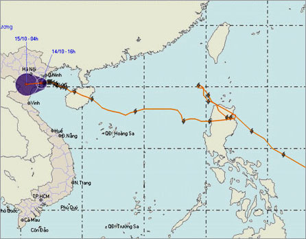
Maintaining for 17 days, Typhoon Parma has swept across Luzon Island (Philippines) twice, into the East Sea twice.(Photo: NCMHF)
Mr. Thao analyzed, entering the East Sea for the first time (October 4), Parma reached level 12, is very strong, but still weaker than hurricane Melor in the eastern Philippines (level 15-16). Due to the distance of two storms less than 2,000 km, Melor was stronger so he " dragged " Parma back to Luzon Island (Philippines) a second time and raged in the island for 3 days causing heavy rain and landslides.
On October 9, escaping from the restraint of Melor, Typhoon Parma returned to the East Sea, the intensity of level 8 and following its trajectory was west-northwest, targeting Hainan Island (China). In theory, entering the island, having friction, again at the end of life, the storm will weaken. Radio Japan thus predicted a weakening storm into a tropical depression. However, it was not weak, but strengthened by 2 levels and 10 levels into the Gulf of Tonkin.
Explaining this extra strength, Mr. Thao said: " Going into the Gulf of Tonkin, meeting the open environment, the sea temperature is not low, adding more energy to the storm. Another reason is the cold air component from Trung. The country is overflowing to the North, the distant interaction with the cold air has made the pressure difference in and out of the storm increase, creating conditions for the storm to intensify.After entering Bach Long Vi, the storm reaches level 10 ".
According to Mr. Thao, on the afternoon of October 13, when crossing Bach Long Vi island, there appeared a new form of weather that made the storm slow down. " Because it is slow, it causes rain and the longer it is in the end of life, the storm decreases its energy and weakens. Another important reason is October 13 afternoon and night, cold air overflows, making temperature the air dropped to 20-21 degrees Celsius, the sea water got cold, the mass of dry and cold air penetrated deeply, causing the storm to have no chance to maintain strength, "Mr. Thao explained.
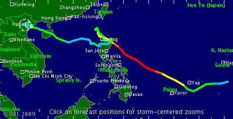
Way to storm Parma by Tropical Storm Risk
Because of the troubled road, sometimes weakened to level 8, so in many localities there was a subjective psychology. Therefore, on the afternoon of October 13, when the typhoon was strong from level 8 to level 10, causing damage to Bach Long Vi Island (Hai Phong), Deputy Prime Minister Hoang Trung Hai had an emergency meeting, asking the provinces from Quang Ninh went to Ha Tinh to be urgently evacuated, to be on high alert. The deputy prime minister ordered no later than 22 pm at night to complete the task of preventing storms. 3 missions of the central accelerator on the afternoon of October 13 must go to the crucial areas.
During the afternoon and last night, the northern coastal provinces and the North Central Coast had to evacuate nearly 30,000 people in coastal areas and areas of landslide risk to a safe place. During the night, people and people involved in flood and storm control were almost completely awake to storm the land. Because according to the Director of the Center, the central hydro-meteorological forecast of Bui Minh Tang, the storm will land in the provinces from Thai Binh to Thanh Hoa from 1 to 3 am on October 14. Hai Phong and Quang Ninh provinces are also affected by cold air combined with storms.
But in the end the storm did not enter as predicted, but went down south and until 16:00 on October 14, it weakened into a tropical depression when approaching the coast of Hai Phong - Ninh Binh provinces.
Talking to VnExpress on the afternoon of October 14, Mr. Dien, Chief of the Office of the Steering Committee for Flood and Storm Prevention and Control of Thai Binh Province, said: " During the night, when I was awake, my wife was angry because she did not go home to take care of the storm but just kept going. But it is very fortunate that the storm has melted, everything is good, there is no damage .
From Nam Dinh, Mr. Do Van Khanh, Head of the provincial management of dyke and flood control, said that Parma storms are in many coastal districts, causing only strong winds of level 5-6, causing small rain and ending. This afternoon has not caused any damage. Sea dikes are safe.
Formed from a tropical depression in the eastern part of the Philippines on September 28, Typhoon Parma was influenced by super typhoon Melor, so the road was very bizarre. Typhoon has twice swept across Luzon Island (Philippines), twice went to the East Sea and created many knots along the way. Scanning through the Philippines for the first time, the storm killed at least 16 people. The second time came back, the storm caused heavy rain, landslides caused 160 deaths.
- Typhoon Parma and Melor are very strong and complex
- Taiwan evacuated 6,000 people before typhoon Parma
- The law explains why sometimes we say we want to achieve something but give up a few days later
- Typhoon Parma is complicated
- Philippines copes with new super typhoon
- On the evening of December 11, the 5th hurricane will land
- Tropical storm Isaac has a trajectory like Katrina
- Vietnam may face new super typhoons
- Beam: Super storm Sandy devastated America
- More than 30 people died from Hurricane Harvey
- Broken pavement, sunken cars in super storm Hato in China
- Hurricane Nock-ten 'ensembles' South China Sea, wind gusts of level 14
 Is the magnetic North Pole shift dangerous to humanity?
 Washington legalizes the recycling of human bodies into fertilizer
 Lightning stone - the mysterious guest
 Stunned by the mysterious sunset, strange appearance