Vietnam may face new super typhoons
With strong winds of level 15-16, after passing through Philippies, Typhoon Parma could enter the South China Sea and head to Vietnam, while the Central region was overcoming the consequences of the storm No. 9.
This morning, according to the Philippine Meteorological Agency, super typhoon Parma has a wind speed of 15-16 moving at a speed of 20 km per hour, which is only 270 km away from the island of Catanduanes of the country. On October 4, after landing in the northern Philippines, super typhoon Parma could enter the South China Sea.
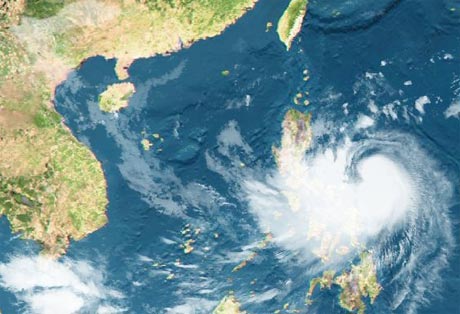
Hurricane Parma taken from satellites at 23:30 on October 1.( Photo: NEA, Singapore).
The US Navy Radio forecast, on October 3, after passing Palaui Island (Philippines), super typhoon Parma changed direction, went to the East Sea and headed straight for Vietnam. Despite reducing energy after going on land, on October 6, Parma still had winds of 154-177 km per hour, stronger than the 9th storm that had just entered Central.
This forecast also coincides with the information given by some meteorological agencies of Japan, Taiwan, University of Hawaii . this morning.
Off the Pacific Ocean, about 2,000 km from the super typhoon Parma, the storm Melor has strong winds of level 13-14. However, Melor is heading towards Japan.
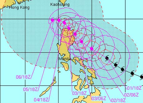
US Naval Station predicts the path of Typhoon Parma.(Photo: JTWC)
After passing through the Philippines, 300 people were killed in the country, typhoon Ketsana (typhoon 9) hit Vietnam again, killing nearly 100 people, causing trillions of dong. Following the storm is a historic flood that threatens the lives of people in Central and Central Highlands.
In the afternoon of October 1, Prime Minister Nguyen Tan Dung inspected the flooding area and decided to provide emergency assistance of 10,000 tons of rice and 460 billion VND to the central provinces.
- The idea of beating super typhoons with US nuclear bombs
- The trio of super typhoons are raging on the Atlantic
- Scary phenomena can occur in super typhoons
- The secret to watch the face read the personality in just 1 minute
- The most intense super typhoons in the history of the Atlantic
- The worst natural disaster is still ahead
- Plankton contribute to super typhoons
- Hanoi plans to respond to super typhoon Mangkhut
- 2010: Year of natural disaster
- Super Typhoon Haiyan and questions about climate change
- China worries about chemical disasters because of super typhoons
- The image of Super Moon is 70 years only once in Vietnam
 Is the magnetic North Pole shift dangerous to humanity?
 Washington legalizes the recycling of human bodies into fertilizer
 Lightning stone - the mysterious guest
 Stunned by the mysterious sunset, strange appearance