Appearing low pressure area in the South China Sea
In the next 24 to 48 hours, the low pressure has the ability to change the direction of travel in the Northwest direction, each hour is 10-15 km and is capable of strengthening into a tropical depression.

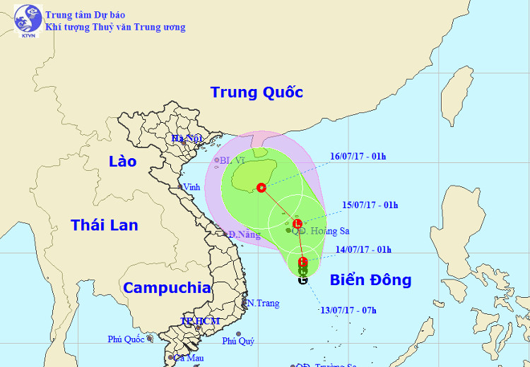
Photo of path and low pressure area.(Photo: nchmf).
The Central Center for Hydrometeorological Forecasting said that at 01:00 on July 14, the central position of the low pressure area is about 14.0-15.0 degrees North latitude; 112,0-113,0 Kinh Dong, about 270km south of the Paracel Islands south of Southeast.
Forecast in the next 24 hours , low pressure moves mainly in the North, about 10km per hour. At 01:00 on July 15, the position of the center of the low pressure area is about 16.7 degrees Vi Bac; 112.2 degrees east longitude, right in the waters of the Paracel Islands.
In the next 24 to 48 hours , the low pressure has the ability to change the direction of travel in the Northwest direction, each hour is 10-15 km and is capable of strengthening into a tropical depression.
Due to the influence of low pressure circulation in combination with the operation of the southwest monsoon, the area between the South and South China Sea (including the waters of Truong Sa archipelago) and the sea area from Ninh Thuan to Ca Mau and Ca Mau to Kien Giang and the Gulf of Thailand showers and strong thunderstorms. In the thunderstorm there is the possibility of tornadoes and strong winds of level 6-7. Disaster risk level: level 1.
- Appearing low pressure area on the East Sea, can be directed towards Vietnam
- The South China Sea is about to be stormed, warning of heavy rain
- Beware of tropical depressions in the South China Sea
- A low pressure area appeared in the East Sea
- Appearing low pressure area on the Gulf of Thailand, the Central continued heavy rain
- Start a new heat wave with low pressure
- Hurricane Pakhar and tropical depression are
- Stormy season, tropical low pressure will come soon in the South China Sea
- This afternoon, the new low pressure is close to South Central and South
- Tropical depressions cause large areas of rain
- Tonkin is sunny, the temperature can be up to 34 degrees Celsius
- There was a tropical depression again
 Is the magnetic North Pole shift dangerous to humanity?
 Washington legalizes the recycling of human bodies into fertilizer
 Lightning stone - the mysterious guest
 Stunned by the mysterious sunset, strange appearance
 What is a weather bomb and how powerful is it?
  Why do we feel 'suffocated' when under pressure?
  Why is hypertension getting younger?
  Korean scientists develop a method to quickly produce diamonds in 150 minutes
  Scientists turn spider corpses into 'zombie robots'
  What is the negative pressure room to isolate Covid-19 patients?