There was a tropical depression again
On the afternoon of January 22, a low pressure area in the middle of the East Sea became stronger into a tropical depression. With strong intensity level 6, low pressure is moving in the West, targeting the South Central Coast. However, the direction of movement of low pressure is likely to change, due to the impact of cold air from the North that is overflowing.
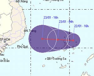
Predict the path of the tropical depression.
(Photo: NCHMF)
The Central Hydrometeorological Center warns, tropical depressions combined with cold air will cause gusts of wind above level 7 off the central coastal provinces, the north and the middle of the East Sea (including Spratly Islands. Strong sea.
This is the second tropical depression of the season this year. Previously, on January 13, a tropical depression in the East Sea appeared. Before being chilled away from Vietnam by cold air, it has caused moderate rain in the Southern Central and Southern provinces.
Typically, storms and tropical depressions appear in the South China Sea from May to December, most concentrated in August-November. Rarely do they appear late in early January of the following year.
Hong Khanh
- Tropical depression Kajiki weakened in the East Sea
- Tropical depressions move quickly at sea, with the possibility of strong storms
- Storm No. 13 weakens into a tropical depression
- Tropical depressions landed on the East Sea
- Tropical depression at level 8 formed in the South China Sea
- Appears tropical depression near the East Sea
- Tropical depression intensified into storm No. 3
- Latest news about two tropical depressions consecutively in the South China Sea
- Typhoon Tembin weakened into a tropical depression
- Tropical depression towards the East Sea
- Appearing low pressure area in the South China Sea
- Tropical depressions cause heavy rain and thunderstorms
 Is the magnetic North Pole shift dangerous to humanity?
 Washington legalizes the recycling of human bodies into fertilizer
 Lightning stone - the mysterious guest
 Stunned by the mysterious sunset, strange appearance