A new low pressure appears, potentially strengthening into a storm
Currently, a tropical depression is operating in the southern region (Philippines).
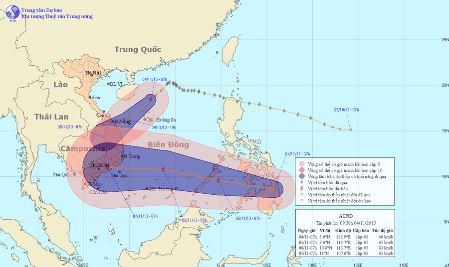
At 07:00 on November 4, the position of the tropical depression center was about 8.6 degrees Vi Bac; 125.9 degrees Kinh Dong, in the southern coastal region (Philippines). The strongest wind in the area near the center of strong tropical depression at level 6 (ie from 39 to 49km per hour), level 7, level 8.

It is forecasted that in the next 24 hours, tropical depressions will move in the direction of West and Northwest Northwest, about 25km per hour and can be increased into storms. By 07:00 on November 5, the location of the storm center was about 9.6 degrees Vi Bac; 119.7 degrees Kinh Dong, about 80km southeast of Pa-la-Oan (Philippines). The strongest winds in the area near the storm center are strong at level 8 (ie 62 to 74 km per hour), level 9 and level 10 jerks.
In the next 24 to 48 hours, the storm moves in the direction of West and West Northwest, about 25km per hour and continues to increase. By 07:00 on November 6, the location of the storm center is about 10.8 degrees Vi Bac; 113.7 degrees Kinh Dong, on the northern region of the Spratly Islands. The strongest winds in the area near the storm center are strong at level 9 (ie from 75 to 88km an hour), level 10 and level 11 jerks.
Due to the impact of the following tropical depressions becoming strong storms, from tomorrow (November 5), the southeast sea of the East Sea, including the eastern sea of Truong Sa archipelago, will have strong winds gradually up. 6, level 7, the area near the center of the storm passes through level 8, level 9, level 10, level 11. The sea is very strong.
This is a storm with fast moving speed, complicated direction, needing regular and complete monitoring.
- Tropical depression towards the East Sea
- Tropical depressions intensified into storm No. 10
- Seventh storm weakened into low pressure, from the afternoon of August 28, Bac Bo had a large rain
- Secret to proactively respond to a big storm
- Storm No. 15 has not melted, near the East Sea, a new storm appears
- This afternoon, the tropical depression strengthened into a storm - the number 9 storm this year
- Tin latest storm No. 3: Lightning storms landed in Hai Phong - Ninh Binh
- Tropical depression strengthened into storm No. 2, heading to Quang Ninh - Hai Phong
- Appearing low pressure area in the South China Sea
- Sanba storms on the Philippines, potentially weakening in the South China Sea
- Suddenly No. 6 storm
- Aere No. 6 storm weakens
 Is the magnetic North Pole shift dangerous to humanity?
 Washington legalizes the recycling of human bodies into fertilizer
 Lightning stone - the mysterious guest
 Stunned by the mysterious sunset, strange appearance