Tin latest storm No. 3: Lightning storms landed in Hai Phong - Ninh Binh
In the past 3 hours, storm No. 3 moved west-northwest, speed of 17 km / h. In Bach Long Vi continue to have strong winds of level 8, level 10 jerks, in Co To and Cua Ong (Quang Ninh) with strong winds of level 10 ; Other places in the North Coast, North Central Coast have strong winds of level 8.
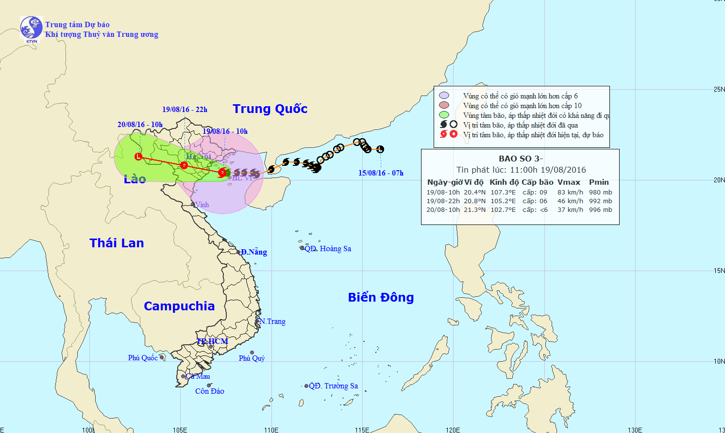
At 11:00 on August 19 , the position of the center of the storm No. 3 was about 20.5 degrees North latitude; 107.3 degrees Kinh Dong, on the waters of Quang Ninh-Nam Dinh. The strongest wind is in the area near the storm center with strong level 9 (75-90km / hour), level 10-12 shock.
It is forecasted that in the next 6 hours (until 14h of August 19) , the storm will move in the direction between West and West Northwest, every hour is 15-20km, continue to affect directly to the provinces in the North and the North. Nave. By 17:00 on August 19, the location of the storm center is about 20.7 degrees Vi Bac; 106.4 degrees Kinh Dong, on the mainland of Quang Ninh-Thai Binh provinces. The strongest wind is in the area near the center of the typhoon with a strong level of 8-9 (60-90km / hour), level 10-12 shock.

The path of the storm No. 3.
Due to the impact of typhoons, in the Gulf of Tonkin (including Bach Long Vi, Cat Hai, Co To and Van Don districts), there are strong winds of level 8, the area near the center of the storm passes through level 9, level 10 jerks -12, sea waves 3-5m high. The sea is very strong. Level 3 disaster risk level.
In Quang Ninh, Hai Phong, Thai Binh, and Nam Dinh provinces, there are strong winds of 8-9, level 10-12. Ninh Binh continues to have strong winds of level 7, level 9-10. The coastal area from Quang Ninh to Thai Binh has storm surges combining high tide of 3.0-3.5m. Level 3 disaster risk level.

It is forecasted that in the next 6 to 12 hours , the storm will move in the West, about 20km per hour, going deep into the mainland and weakening into a tropical depression. By 22:00 on August 19 , the position of tropical depression was about 20.8 degrees Vi Bac; 105.2 degrees east longitude, on land of the northern delta provinces. The strongest wind is in the area near the strong tropical depression at level 6-7 (40-60km / hour), level 10-12.
In Quang Ninh, Hai Phong, Thai Binh and Nam Dinh provinces, strong winds of level 7-9, level 10-12 shock are continued. Provinces of Lang Son, Bac Giang, Bac Ninh, Hai Duong, Hung Yen, Ha Nam, Ninh Binh, Thanh Hoa have strong winds of level 6, shock level 7-8.

Satellite image of location and path of storm No. 3.
The Hanoi area has winds of level 6-8 and rain of 100-200mm.
In the next 12 to 24 hours, tropical depressions move mainly in the West direction, each hour is 15-20km, going deep into the mainland and weakening into a low pressure area in upper Laos area.
- Storm No. 1 attacked Quang Ninh, Hai Phong
- Tonight the storm landed Hai Phong, Thai Binh and Quang Ninh
- Typhoon hit Quang Ninh
- Storm No. 7 can enter Quang Ninh - Hai Phong
- No.1 storm suddenly changed direction, can go through Hai Phong, Hanoi
- Storm level 10 is directed at Quang Ninh - Hai Phong
- 19h tonight, the storm center is located on the waters of Quang Ninh - Hai Phong
- Typhoon hit Quang Ninh, Hai Phong
- Storm No. 3 is about 180km from Quang Ninh - Hai Phong
- Low pressure to become a storm, landed in Ha Tinh - Quang Binh
- Tropical depression into storm Damrey, threatening Binh Dinh - Ninh Thuan
- Tonight, Bac Bo rains lightly, there is a place of heavy rain due to the effects of storms
 Is the magnetic North Pole shift dangerous to humanity?
 Washington legalizes the recycling of human bodies into fertilizer
 Lightning stone - the mysterious guest
 Stunned by the mysterious sunset, strange appearance