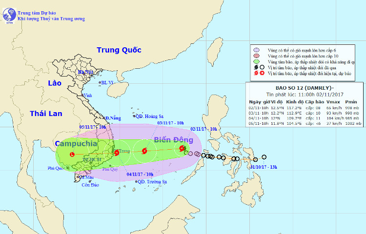
Tropical depression into storm Damrey, threatening Binh Dinh - Ninh Thuan
On the morning of November 2, the depression officially became a typhoon of the year 12, the international name was Damrey, the wind speed was level 14 (more than 150km / h) at the center of the storm.
At 10 o'clock , the location of the center of the storm is about 12.5 degrees north latitude; 117.2 Kinh Dong, about 340km from Song Tu Tay Island to the East North East. The strongest wind is in the area near the center of the typhoon with a strong level of 8-9 (60-90km / hour), level 11 shock.
It is forecasted that in the next 24 hours , the storm will move mainly in the West, about 20km per hour and there is a strong possibility. At 10 am on November 3, the location of the storm center is about 12.2 degrees North latitude; 112.9 Kinh Dong, about 400km from the coast of Binh Dinh-Ninh Thuan provinces to the East. The strongest wind is in the area near the center of strong storm 9-10 (75-100km / hr), level 14 jerks.

Direction of storm No. 12.
Due to the impact of the storm, the area between the South China Sea (including the North Sea of the Spratlys) has showers and strong thunderstorms, strong winds of level 6-7, the area near the center of the storm passes through levels 9-10, shock level 13-14; The sea is very strong. In the next 24 hours, the area is dangerous (strong wind from level 6 or higher) in about 10-14 degrees North latitude; East 111.0 degrees Kinh Dong. Disaster risk level: Level 3.
It is forecasted that in the next 24 to 48 hours , the storm will move in the West, then it is possible to change the direction of moving West-West Southwest, about 15km per hour and continue to increase. By 10 o'clock on November 4, the location of the storm center is about 12.0 degrees North latitude; 109.7 degrees Kinh Dong, on the waters of Binh Dinh-Binh Thuan provinces.
The strongest wind is in the area near the center of strong storm level 10-11 (90-115km / hour), level 14 jerks.
The forecast for the next 48 to 72 hours , the storm moved in the West, about 20km per hour.
Strong wind warning on the sea: Due to the effects associated with cold air, from tonight (November 2), in the waters off the central and southern central provinces, strong winds gradually rise to level 6-7, level up. 9; strong sea.
- Weather forecast today
- Storm No. 14 weakens into a tropical depression
- Storm No. 1 is 350km from the coast of Ninh Thuan-Binh Thuan
- Tropical depression strengthened into a typhoon No. 5, heading to Binh Dinh - Phu Yen
- Tropical depressions melted, the flood in the Central region increased quickly
- Tropical depressions, Binh Thuan to Ca Mau prevent cyclones and waves of 4m high
- Why is the number 12 typhoon closer to the shore?
- Entering the capital of Hanoi, the storm weakened into a tropical depression
- Storm No. 12 targets Khanh Hoa - Ninh Thuan, winds of 130km / h
- Tropical depressions come ashore, many places are heavy rain
- Tropical depression strengthened into storm No. 2, heading to Quang Ninh - Hai Phong
- Planning 5 provinces with nuclear power plants
- Two people died, thousands of houses were blown away by the storm
 Is the magnetic North Pole shift dangerous to humanity?
 Washington legalizes the recycling of human bodies into fertilizer
 Lightning stone - the mysterious guest
 Stunned by the mysterious sunset, strange appearance