Typhoon hit Quang Ninh
At 10 am this morning, the storm of Jebi entered Quang Ninh province with strong winds of level 9 (maximum winds of 102km per hour). The storm stormed many corrugated iron and billboards. Storm circulation causes rain throughout the North East and Thanh Hoa.
>>>Emergency response to hurricane Jebi
In Quang Ninh , where the storm center passes, the wind becomes stronger and stronger. At 10am, from Mong Cai to Hoanh Bo, Bai Chay with big rain, high winds appear causing many trees to collapse. Many billboards and corrugated iron were also jolted.
Before the storm came, Quang Ninh moved people in critical areas, people living in cages to safety. The province also banned the sea from yesterday, prohibiting all tourist vehicles operating on Ha Long Bay.

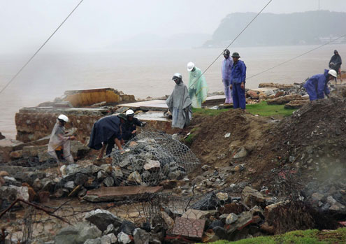
At 10 am this morning, the embankment of Do Son district (Hai Phong) is still being strengthened by the force.(Photo: Quoc Bien)
In Hai Phong , close to storms, 10 am along the embankment of Do Son district, the waves still remain, but the wind is very strong. At some landslides in Typhoon Bebinca (landfall on June 23), functional forces are actively making reinforcement gabions, preventing sea waves from causing landslides. As predicted, ocean waves with high tides can make sea level rise 3-5m.
The streets of the famous tourist area in the North are deserted, only a few people wearing raincoats go out to check against the house.
Earlier on August 2, Typhoon Jebi crossed north of Hainan Island (China), entered the Gulf of Tonkin with strong winds of level 10 (equivalent to 100km / h). At Bach Long Vi island station, strong winds of 17m / s are measured (level 7); on Co To Island, the wind jerked up to 18m / s (level 8). At the measurement point in the mainland in Mong Cai (Quang Ninh), there was also a windstorm of 15m / s (level 7). After entering the Gulf of Tonkin, the storm is weakening.

The row of cucumber in Do Son beach shed.(Photo: Quoc Bien)
The central hydro-meteorological center said that the storm will land at around 10 am this morning, the storm center hits the area between Bai Chay and Mong Cai (Quang Ninh) with the wind down to level 7, pressure level tropical low. Particularly for islands like Bach Long Vi, it is possible to wind up to level 9. After landing, the depression departs deep into the mainland of the Northeastern provinces and continues to weaken.
Deputy director of meteorological center Le Thanh Hai said, with the intensity of typhoon Jebi, the most worrisome thing now is rain. Storm circulation will drain 200-300 mm of rainfall throughout the Northeast in two days 3-4 August. Heavy rain will focus on tonight."It is necessary to take special precautions against flash floods, landslides in mountainous areas and flooding, flooding in delta and urban areas," Hai said.
In addition, storm surges also cause heavy rain for the North Central region. The provinces of Thanh Hoa, Nghe An and Ha Tinh may rain 100mmm.
- Quang Ninh suddenly interested in Typhoon Haiyan
- Typhoon landed from Quang Ninh to Nam Dinh
- Typhoons in Quang Ninh cause flooding in Mong Cai, Hanoi and heavy rains threaten to flood many streets
- Storm No. 7 can enter Quang Ninh - Hai Phong
- Typhoon Mujigae can land in Quang Ninh - Hai Phong
- Tonight the storm landed Hai Phong, Thai Binh and Quang Ninh
- This evening the storm directly affects Quang Ninh - Hai Phong
- Storm No. 2 is about 590 km from the coast of Quang Ninh and Hai Phong
- Actively prevent storm Kai-Tak
- Entering the capital of Hanoi, the storm weakened into a tropical depression
- This afternoon, Typhoon Nesat landed in Quang Ninh - Nam Dinh
- Typhoon Haiyan weakens gradually and goes to China
 Is the magnetic North Pole shift dangerous to humanity?
 Washington legalizes the recycling of human bodies into fertilizer
 Lightning stone - the mysterious guest
 Stunned by the mysterious sunset, strange appearance
 2024 Atlantic Hurricane Season Ends, Leaving Widespread Damage in Its wake
  Storm No. 9 Manyi, level 12, about 200km from Hoang Sa archipelago
  Video: Close-up of the terrible path of the Habood dust storm, causing 15 thousand people in the US to lose power
  Typhoon Tra Mi forms in the East of the Philippines, likely to strengthen into a hurricane when entering the East Sea
  Storm Trami will reach its maximum intensity when it approaches the Paracel Islands.
  Storm Tra Mi enters the East Sea today, strange movement direction