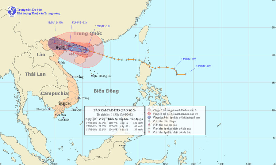
This evening the storm directly affects Quang Ninh - Hai Phong
At 10 o'clock on August 17, the location of the storm center is about 20.9 degrees North latitude; 110.7 degrees Kinh Dong, about 320km from Mong Cai (Quang Ninh) to the East of Southeast. The strongest winds in the area near the storm center are strong at level 12 (ie, from 118 to 133 km per hour), shocking level 13, level 14.
It is forecasted that in the next 12 hours, the storm will move in the direction of West and West Northwest, about 25km per hour. At 22:00 on August 17, the location of the storm center is about 21.6 degrees North latitude; 107.6 Kinh Dong, right on Quang Ninh province. The strongest wind in the area near the storm center is strong at level 8 (ie 62 to 74km per hour), level 9 and level 10 jerks.

Beam photos of the path and location of the storm
In the next 12 to 24 hours, the storm moved in the direction of West and West Northwest, about 25km per hour, going deep into the mainland and weakening into a low pressure area. At 10 am on August 18, the central location of the low pressure area is about 22.1 degrees North latitude; 104.9 degrees Kinh Dong, in the northern mountainous provinces. The strongest wind in the center of the low pressure area falls below level 6 (ie below 39km per hour).
Due to the impact of storms, the southeast sea of Guangdong Province (China) today (August 17) there are strong winds of level 9, level 10, the area near the center of the storm passes through level 11, level 12, jerks 13, level 14. The sea is fierce. In the north of the Gulf of Tonkin (including the islands of Co To, Van Don, Cat Hai and Bach Long Vi) from this afternoon (August 17), the wind will gradually increase to level 7, level 8, near the center. Storm level 9, level 10, shock level 11, level 12. The sea is very strong. In the provinces of Quang Ninh - Hai Phong in the afternoon and tonight, there are strong winds of level 7, level 8, shock level 9, level 10; Other places in the North East have strong level 5 winds, level 6 jerks. In the Northern provinces, there is a moderate rain and heavy rain.
In addition, due to the strong influence of the southwest monsoon, the area between the South and the South China Sea (including the Spratlys waters), the waters from Binh Thuan to Ca Mau have strong winds of level 6, jerky. Sea level 7, level 8.
- Storm No. 1 attacked Quang Ninh, Hai Phong
- Storm level 10 is directed at Quang Ninh - Hai Phong
- Storm No. 7 can enter Quang Ninh - Hai Phong
- Typhoon hit Quang Ninh, Hai Phong
- Storm No. 3 is about 180km from Quang Ninh - Hai Phong
- This afternoon and evening, the storm No. 4 will land on land
- Typhoon Mujigae can land in Quang Ninh - Hai Phong
- Tropical depression strengthened into storm No. 2, heading to Quang Ninh - Hai Phong
- Tonight the storm landed Hai Phong, Thai Binh and Quang Ninh
- 19h tonight, the storm center is located on the waters of Quang Ninh - Hai Phong
- Typhoon landfall in Quang Ninh - Nam Dinh, heavy rain up to 400mm, 4.0-4.5m rise
- Hurricane Kalmaegi is level 13, going straight to the waters of Quang Ninh - Hai Phong
 Is the magnetic North Pole shift dangerous to humanity?
 Washington legalizes the recycling of human bodies into fertilizer
 Lightning stone - the mysterious guest
 Stunned by the mysterious sunset, strange appearance