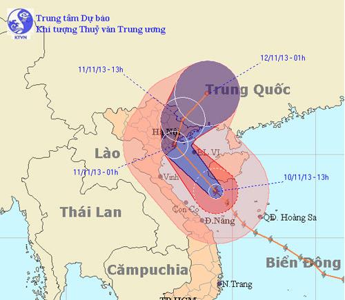
Tonight the storm landed Hai Phong, Thai Binh and Quang Ninh
Haiyan is continuing to move north and soon is 10pm tonight, latest at 3-4h tomorrow morning, the storm center goes into the three provinces of Hai Phong, Thai Binh and Quang Ninh.
This afternoon, Mr. Bui Minh Tang, Director of the Central Center for Meteorological and Hydrological Forecasting, said that, instead of going to the North Central and southern provinces of the Northern Delta, the new information shows that the storms fall. The direct set will be the Northern Coast. In the North Central region, back to this point is basically a safe area.

The expected path of Typhoon Haiyan in the newsletter broadcast at 17:30 this afternoon of the Central Center for Meteorological and Hydrological Forecasting
According to Mr. Tang, the Center for Meteorology has consulted the forecasts of centers around the world but they have not yet agreed.
Japan predicted storms to arrive at midnight on the morning of November 11, the point of landfall from Ha Tinh to Thai Binh, then the storm weakened and then moved to Viet Bac mountain area. The storm center dissipated in the mountains around Bac Can, Tuyen Quang.
Hong Kong, China, and US stations said that the storm would go between Hai Phong and Quang Ninh, then cross over to Quang Ninh and weaken when going to China.
'We are more likely to storm between Thai Binh and Hai Phong, then enter the middle of the province such as Bac Giang, Hai Phong and Quang Ninh, then change north to Quang Ninh territory and then to China.' , Mr. Tang said.

Border guards call fishermen take boats to avoid storms in Co To Island, Quang Ninh.(Photo: Ninh Hang)
The Northern coast from Ninh Binh to Quang Ninh will have a strong wind of more than 74km / h. The center of the storm is Thai Binh, Hai Phong and Quang Ninh with strong winds of 102km / h.
Inland provinces such as Hung Yen, Bac Giang, Lang Son and even Hanoi will have strong winds of about 49km / h, and inland provinces are not worrisome.
Regarding the rain situation, Mr. Tang said, because the storm moved up to the latitude quite high, so the rain in Central Central to Quang Binh was not large; Wind from Ha Tinh to Thanh Hoa is not dangerous.
The whole of Tonkin, except west of Dien Bien and Lai Chau, does not rain or rain significantly. Other localities have rain and prevent heavy rain in the Northern Delta region, coastal provinces, part of the northern midland mountainous area when some places have rainfall up to 200-300mm.

19h, Ha Long and Quang Ninh streets appear raining.(Photo: Dang Ninh)
Hai Phong: The Do Son area has started heavy rain, the waves hit the white dyke. Hai Phong City People's Committee Chairman Duong Anh Dien asked all forces to be ready to fight storms. More than 4,000 vehicles with nearly 13,000 workers returned to storm shelter. Vehicles that intentionally go to sea will be coerced and fined.
The city requested the border guards, police and relocated laborers in clam watchers in Cat Hai and Trang Cat to the mainland. At 15:00, all ferry terminals stop operating, ships carrying tourists from Hai Phong to Cat Ba are also banned at 15:00, the afternoon of Cat Ba - Hai Phong stops before 17:00. The city also has a plan to relocate more than 46,000 people in districts with the motto of on-site migration to permanent high-rises such as schools and cultural houses .

Border guards help people of Cat Hai island district evacuate from dangerous areas.(Photo: Hoang Thuy)
The City Military Command said it mobilized more than 1,500 mobile soldiers to be ready for rescue, especially the critical dykes of Do Son, the dike Hoang Chau, Trang Cat and Vinh Quang . Search and rescue vessels will anchor at critical positions (Phu Long - Cat Hai Area) to be ready for rescue.
Quang Ninh has a small rain, the wind starts to strong. It's gray. Mr. Hoang Cong Dang, Deputy Director of the Provincial Department of Agriculture and Rural Development said, the Department has divided into groups to monitor the flood prevention in communes, especially sea dykes and areas at risk of landslides. .
This afternoon, all boats were safely anchored. People in raft houses in the area of Ha Long, Cam Pha and Van Don were taken to the mainland to avoid storms. "At the moment, the tide is low, so if there is heavy rain, it is not very disturbing. The department also has a plan for flood drainage in all rivers, lakes, dams . in the area."
Thai Binh: By this evening, the recorded wind level is not too big, the rain is scattered lightly. Deputy Director of the Department of Agriculture Le Van Thang said: "The storm has a fast speed and is complicated, so we keep monitoring to ensure it is not passive".
According to Mr. Thang, on the afternoon of November 10, 100% of boats and ships have been anchored in the shore, the work of relocation to a safe place has also been completed. Fearing that the people see the low tide coming back to the coastal farming area, the province directs the police, border guards and militia forces to close and check.
Water in the Thai Binh inland area is very low, the bottom of the river bed is a bottom for local drainage. The department is also willing to open the river mouth if the rainfall is heavy.
Hanoi will not seriously flood
According to the previous scenario, when the storm entered Central Vietnam and weakened Laos, the rain in Hanoi and North Vietnam was very large. But with the latest scenario, Hanoi rain may be only around 100mm in the night and tomorrow morning.
"With the above rainfall if it is about 12 hours or more, Hanoi is not worrisome, but if it is within 1-2 hours, it will cause local flooding. However, in my opinion, in Hanoi, it may not be serious. , or cause traffic disturbances, " Mr. Tang said.
This morning after going to the southern part of the Gulf of Bac Bo, the storm moved to the northwest, the speed decreased to about 25-30km per hour, the intensity of the storm also decreased at the beginning of level 13. The location of the storm center is at horizontal latitude between Ha Tinh, southern Nghe An (Ben Thuy), 200km from the North Central Coast coast to the east, about 250-300km from the Northern coastal provinces.

The people of Thanh Hoa issue a set to prevent dike against storms in the afternoon of November 10.(Photo: Le Hoang)
This evening, the storm moved quickly in the direction between northwest and north northwest with the speed of about 30-35km, going to the coast of the northern provinces of the North, the storm center landed at this moment are the three provinces of Hai Phong, Thai Binh and Quang Ninh.
- Storm No. 1 attacked Quang Ninh, Hai Phong
- Storm level 10 is directed at Quang Ninh - Hai Phong
- 19h tonight, the storm center is located on the waters of Quang Ninh - Hai Phong
- Storm No. 7 can enter Quang Ninh - Hai Phong
- Typhoon hit Quang Ninh, Hai Phong
- Typhoon hit Quang Ninh
- Storm No. 3 is about 180km from Quang Ninh - Hai Phong
- Urgently evacuate people during the night because of storm No. 10
- Tin latest storm No. 3: Lightning storms landed in Hai Phong - Ninh Binh
- This evening the storm directly affects Quang Ninh - Hai Phong
- Typhoon Mujigae can land in Quang Ninh - Hai Phong
- Typhoon landfall in Quang Ninh - Nam Dinh, heavy rain up to 400mm, 4.0-4.5m rise
 Is the magnetic North Pole shift dangerous to humanity?
 Washington legalizes the recycling of human bodies into fertilizer
 Lightning stone - the mysterious guest
 Stunned by the mysterious sunset, strange appearance