Actively prevent storm Kai-Tak
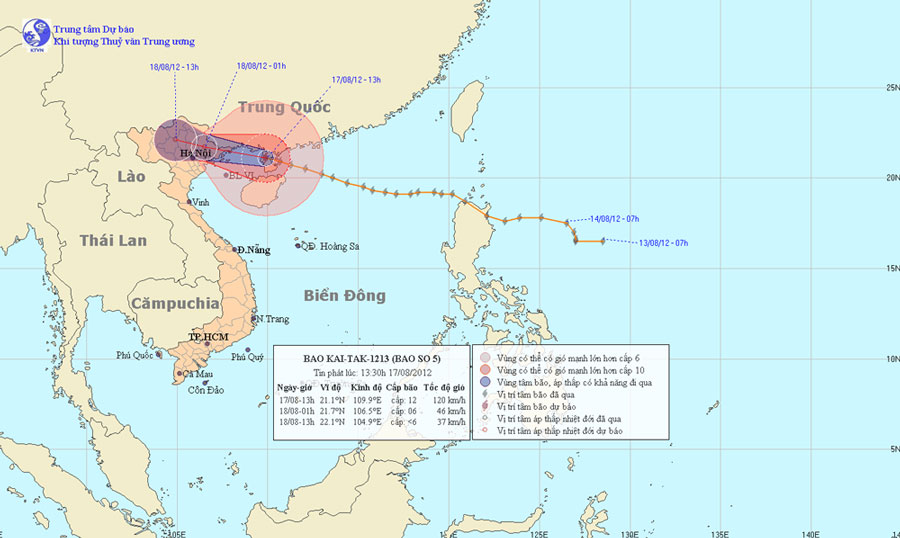
At 13:00 on August 17, the location of the center of the storm was about 21.1 degrees north latitude; 109.9 Kinh Dong, on the northwestern area of Leizhou Peninsula (China), about 200km from Mong Cai (Quang Ninh) to the East of Southeast . The strongest winds in the area near the storm center are strong at level 11, level 12 (ie from 103 to 133 km per hour), shock level 13, level 14.
It is forecasted that in the next 12 hours, the storm will move in the direction of West and West Northwest, about 25km per hour. Thus, in the evening, the storm will enter the North-eastern provinces of the North and weaken into a tropical depression. At 01:00 on August 18, the position of the tropical depression center is about 21.7 degrees Vi Bac; 106.5 degrees east longitude, right on the northeast mountainous area. The strongest wind in the area near the center of strong tropical depression at level 6 (ie from 39 to 49 km per hour), level 7 jerks.
Beam photos of the path and location of the storm
In the next 12 to 24 hours, the tropical depression moves in the direction of West and Northwest Northwest, about 25km away every hour and weakens into a low pressure area. By 13:00 on August 18, the central location of the low pressure area was about 22.1 degrees North latitude; 104.9 degrees Kinh Dong, in the northern mountainous provinces. The strongest wind in the center of the low pressure area falls below level 6 (ie below 39km per hour).
Due to the impact of storms, the northern sea of the Gulf of Tonkin (including the islands of Co To, Van Don, Cat Hai and Bach Long Vi) has strong winds of level 7, level 8 and storms near level 9, level 10, shock level 11, level 12. The sea is very strong. In Quang Ninh - Hai Phong provinces, there are strong winds of level 7, level 8, shock level 9, level 10; other places in the North East region with strong winds of level 5, level 6 shock. The coastal areas of Quang Ninh province need to prevent high tides in combination with storm surges of 4 - 5m high. In the Northern provinces, there is heavy rain.
In addition, due to the strong influence of the southwest monsoon, the area between the South and the South China Sea (including the Spratlys waters), the waters from Binh Thuan to Ca Mau have strong winds of level 6, jerky. Sea level 7, level 8.
- Actively respond to storm Nari
- Storm No. 6 is approaching the Vietnam-China border, the North is about to rain very hard
- Need to actively respond to typhoon Kai-Tak
- How to not be struck by thunderstorms?
- Actively respond to hurricane Krosa
- Hurricane Koppu turned to the north
- Tin latest storm No. 3: Lightning storms landed in Hai Phong - Ninh Binh
- Storm No. 15 has not melted, near the East Sea, a new storm appears
- Tropical depression strengthened into storm No. 2, heading to Quang Ninh - Hai Phong
- Storm Dianmu accelerated, Hanoi prepared to catch a storm
- Why is storm No. 10 the first storm in Vietnam to be warned red?
- Standing still for 24 hours, storm No. 4 is about to accelerate
 Is the magnetic North Pole shift dangerous to humanity?
 Washington legalizes the recycling of human bodies into fertilizer
 Lightning stone - the mysterious guest
 Stunned by the mysterious sunset, strange appearance