Tin storm near the shore: Storm No. 3 appeared, heading to Da Nang - Quang Ngai
In the morning of September 14, 2015, the tropical depression turned into a storm with strong wind speed of level 8 (60-75km / h), expected to enter the coast of Da Nang - Quang Ngai this afternoon.
Typhoon 3 hit Da Nang - Quang Ngai
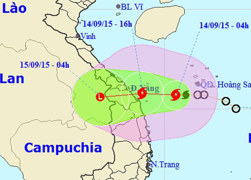
According to the Central Hydrometeorology Center, 4 am this morning (September 14, 2015), the storm center in the southwestern sea of Hoang Sa archipelago, about 220km from the coast of Da Nang - Quang Ngai. The storm has a maximum wind speed of 75km / h, going in the West. By 16:00 this afternoon, the storm in the coastal waters of Danang - Quang Ngai, kept the wind.

Direction of storm No. 3. (Photo: NCHMF).
After that, the storm continued to move westward, at a speed of 10-15 km, going into the mainland of Da Nang - Quang Ngai and weakening into a tropical depression.
Due to the impact of storms, the North Sea (including the Paracel Islands) and the Mid-Central Coast, there are strong winds of level 6-7, level 9-10, strong seas. Coastal Quang Binh - Quang Ngai provinces from this afternoon strong winds level 6-7, level 8-9. In today and the coming days, provinces in the Central, Northern Central Highlands and the whole Northern region have rain and heavy rain.
- The steps needed to survive the super typhoon
Floods from Nghe An to Quang Ngai and the North Central Highlands will occur. Water levels in rivers in Nghe An, Ha Tinh, Thua Thien Hue and Quang Nam are at 1-2 alarm levels; alarming levels of 2-3 in Quang Binh, Quang Tri, Quang Ngai and northern Central Highlands. In these provinces there is a risk of flash floods, landslides in the mountains, low-lying areas.
In addition, the Gulf of Tonkin area has strong winds of level 6-7, level 8-9. In the middle and southern part of the South China Sea (including the Spratly Islands), the offshore waters of Binh Thuan and Ca Mau provinces have strong southwest winds of level 6, level 7-8 and strong thunderstorms; In the storm, there should be a tornado.
This is the third storm to enter the South China Sea in 2015.
- Typhoon No. 3 approaching Quang Nam - Quang Ngai
- Close to Da Nang - Quang Ngai highway 34.5 trillion before September 2 traffic
- This evening, storm No. 5 landed on land from Quang Ngai to Khanh Hoa
- Storm has not arrived, Danang has suffered
- Emergency storm news (Storm No. 4)
- Quang Ninh to Quang Ngai is directly affected by typhoon Kai-Tak
- Cimaron storm toward Da Nang - Quang Ngai
- Typhoon Nakri approached Quang Ngai - Khanh Hoa, the central region had heavy rain
- Emergency storm news (Storm No. 4) - updated
- Typhoon Haiyan is heading into Quang Ngai
- Storm No. 4 jerk level 10, heading to Quang Ninh - Nam Dinh
- Tropical depression strengthened into storm No. 2, heading to Quang Ninh - Hai Phong
 Is the magnetic North Pole shift dangerous to humanity?
 Washington legalizes the recycling of human bodies into fertilizer
 Lightning stone - the mysterious guest
 Stunned by the mysterious sunset, strange appearance