Quang Ninh to Quang Ngai is directly affected by typhoon Kai-Tak
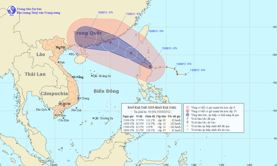
At 07:00 on August 15, the location of the center of the storm was about 17.9 degrees Vi Bac; 122.1 degrees Kinh Dong, on the northern area of Lu - Dong Island (Philippines). The strongest wind in the area near the storm center is strong at level 9 (ie from 75 to 88km an hour), level 10 and level 11 jerks.
It is forecasted that in the next 24 hours, the storm will move in the direction between the Northwest Northwest and the Northwest, about 15 to 20 km per hour and there is also a strong possibility. Thus, around tonight (August 15), the storm will enter the northeast sea of the East Sea. By 07:00 on August 16, the location of the storm center is about 20.3 degrees Vi Bac; 118.7 degrees Kinh Dong, about 810 km east of the Hoang Sa archipelago to the Northeast. The strongest wind in the area near the storm center is strong at level 9, level 10 (ie from 75 to 102 km per hour), level 11 and level 12 jerks.

Beam photos of the path and location of the storm
In the next 24 to 48 hours, the storm moves in the direction between the Northwestern Northwest and the Northwest, about 15 - 20km per hour. At 07:00 on August 17, the location of the storm center is about 22.2 degrees Vi Bac; 115.0 degrees east longitude, about 90km from Hong Kong (China) to the southeast of Southeast. The strongest wind in the area near the storm center is strong at level 9, level 10 (ie from 75 to 102 km per hour), level 11 and level 12 jerks.
In the next 48 to 72 hours, the storm moved west-northwest, about 20km per hour.
Due to the influence of typhoon circulation, the North East Sea in the East Sea has heavy showers and thunderstorms, from noon and this afternoon (August 15) the wind will gradually increase to level 6, level 7, then increase to level 8, region near the center of the storm passes through level 9, level 10, shock level 11, level 12. The sea is very strong. In addition, due to the strong influence of the southwest monsoon, the area between the South and the South China Sea (including the Spratlys waters), the waters from Binh Thuan to Ca Mau have strong winds of level 6, jerky. Sea level 7, level 8.
- Quang Ninh suddenly interested in Typhoon Haiyan
- This evening the storm directly affects Quang Ninh - Hai Phong
- Typhoon No. 3 approaching Quang Nam - Quang Ngai
- Typhoon Nakri approached Quang Ngai - Khanh Hoa, the central region had heavy rain
- Flooding in Quang Ninh left 8 people dead, 6 missing
- Why is Quang Ninh still affected by floods?
- Typhoon landed from Quang Ninh to Nam Dinh
- Typhoons in Quang Ninh cause flooding in Mong Cai, Hanoi and heavy rains threaten to flood many streets
- Storm No. 7 can enter Quang Ninh - Hai Phong
- Typhoon Mujigae can land in Quang Ninh - Hai Phong
- Typhoon into Quang Ninh: Power outages, shipwrecks, flooding
- Tonight the storm landed Hai Phong, Thai Binh and Quang Ninh
 Is the magnetic North Pole shift dangerous to humanity?
 Washington legalizes the recycling of human bodies into fertilizer
 Lightning stone - the mysterious guest
 Stunned by the mysterious sunset, strange appearance