Tropical depressions enter the South China Sea, potentially strong into storms
Tropical depressions are now about 160 km west of Song Tu Tay Island, strong at level 6-7, level 9 and capable of becoming stormy.
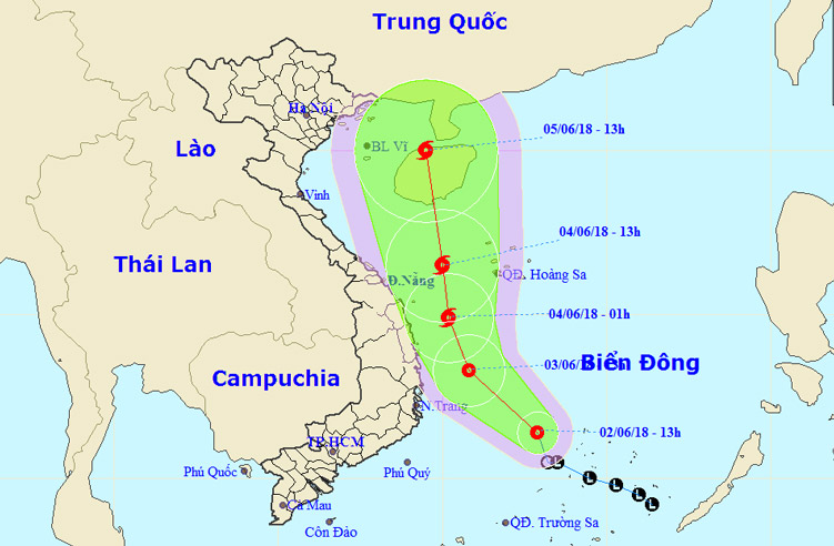
The National Center for Hydrometeorological Forecasting said that the afternoon of June 2, the position of tropical low pressure center is about 160 km to the west of Song Tu Tay Island (Truong Sa archipelago). At this time, strong low pressure level 6-7 (40-60 km / h), shock level 9.
Day and night, tropical depressions move in the north-west direction, velocity of 10-15 km / h and have strong ability. In the afternoon of June 3, the position of the tropical depression center is about 170 km east of the South Central Coast. The strongest wind in the area near the strong tropical low pressure center level 7 (50-60 km / h), level 9 shock.

Location and direction of tropical depression.(Photo: NCHMF.)
Due to the influence of tropical depressions combined with strong southwest monsoon winds, the area in the middle and south of the South China Sea (including the Spratly Islands) has strong thunderstorms. Strong winds of level 6-7, level 9 shock. The waters from Binh Thuan - Ca Mau, Ca Mau - Kien Giang and the Gulf of Thailand have showers and thunderstorms and strong winds.
In the next 2-3 days, tropical depressions move westward slightly, and are likely to become strong storms. If so, this will be the No. 2 storm in 2018.
On June 5-6, the storm kept moving, about 15 km per hour. In the afternoon of June 4, the location of the storm center is about 220 km east of Central Trung Bo coast. The strongest wind in the area near the center of strong storm level 8 (60-75 km / h), level 10 jerk.
After that, the storm continued to move north, about 15-20 km per hour.

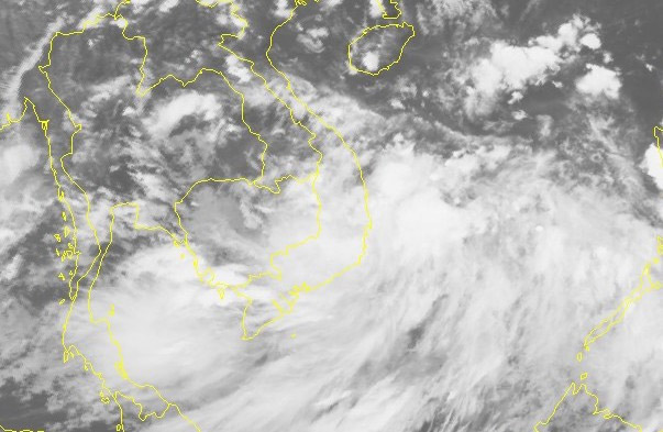
Satellite image of tropical depression.(Photo: NCHMF.)
- Tropical depressions can enter the East Sea in the next 2 days
- Tropical depressions may intensify into storms when approaching the Spratlys
- Tropical depressions are likely to become strong storms heading into the South China Sea
- Tropical depressions approach the South China Sea, potentially increasing into storms
- Occurrence of tropical depression near the South China Sea, the possibility of strong storms
- Tropical depressions are likely to become strong storms towards the North
- Typhoon has just melted, tropical depressions are about to enter the South China Sea
- Vietnam must receive 6-7 storms and tropical depressions
- Tropical depressions into the East Sea are likely to become strong storms
- Tropical depressions are gradually stronger in the South China Sea
- Storms and tropical depressions will appear continuously this year
- Latest news about tropical depression
 Is the magnetic North Pole shift dangerous to humanity?
 Washington legalizes the recycling of human bodies into fertilizer
 Lightning stone - the mysterious guest
 Stunned by the mysterious sunset, strange appearance