Typhoon has just melted, tropical depressions are about to enter the South China Sea
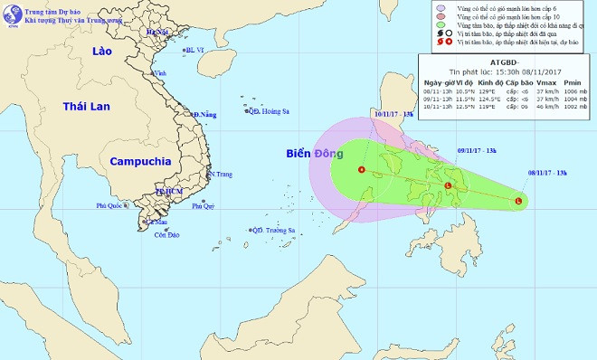
Last night on November 8, the central location of the low pressure area is about 10.5-11.5 degrees North latitude; 126.5-127.5 degrees Kinh Dong, about 220 km from Central Philippines to the East.
It is forecasted that within 24 hours, this low pressure area will move in the West-Northwest direction, about 20km per hour and there will be a strong possibility. By 19:00 on the evening of 9/11, the central location of the low pressure area is about 11.5 degrees North latitude; 124.5 degrees east longitude, in central Philippines.

Location and movement direction of low pressure area near the South China Sea.
The low pressure area moving in the West Northwest direction with the speed of 20-25km / h, continues to increase and is likely to enter the South China Sea on November 10.
In the past 3 hours, there are still heavy rains in Quang Nam, Phu Yen and Dak Lak: Thanh My 23.8mm, Hiep Duc 20.8mm, Tien Phuoc 49.2mm, Song Hinh 92mm, M'Drakk 56.6mm .
The Central Meteorological and Hydrological Center warned that in the next hours, Quang Nam, Phu Yen and Dak Lak provinces will continue to have big to very heavy rain. High risk of flash floods, landslides in mountainous areas of the above provinces. Especially in districts: Quang Nam: Dong Giang, Tay Giang, Bac Tra My, Nam Tra My, Tien Phuoc, Que Son, Hiep Duc and Dai Loc. Phu Yen: Song Hinh. Dak Lak: M'Drak
Due to heavy rains that lasted for many days, many reservoirs were filled with water, the flow to reservoirs continued to be supplemented, high risk of insecurity for the critical reservoirs in the provinces in the above provinces.
In the North , the temperature from now to the end of the week increases steadily. The highest in Hanoi today will be 25-26 degrees Celsius, but sometimes there is a small rain.
In Ho Chi Minh City , sunny days, evening with showers and scattered thunderstorms, showers and thunderstorms at night. During a storm, be aware of strong winds and thunderstorms. The highest temperature is from 32 to 33 degrees. Lowest temperature from 24 to 25 degrees.
- Tropical depressions can enter the East Sea in the next 2 days
- Latest news about two tropical depressions consecutively in the South China Sea
- Tropical depressions are likely to become strong storms heading into the South China Sea
- Tropical depressions enter the South China Sea, potentially strong into storms
- Tropical depressions may intensify into storms when approaching the Spratlys
- Tropical depression at level 8 formed in the South China Sea
- Tropical depressions are gradually stronger in the South China Sea
- Tropical depressions into the East Sea are likely to become strong storms
- Latest news about tropical depression
- Occurrence of tropical depression near the South China Sea, the possibility of strong storms
- Occurrence of tropical depressions in the East Sea, rainstorms all over the country
- New storm entered the Philippines again when Melor just melted
 Is the magnetic North Pole shift dangerous to humanity?
 Washington legalizes the recycling of human bodies into fertilizer
 Lightning stone - the mysterious guest
 Stunned by the mysterious sunset, strange appearance