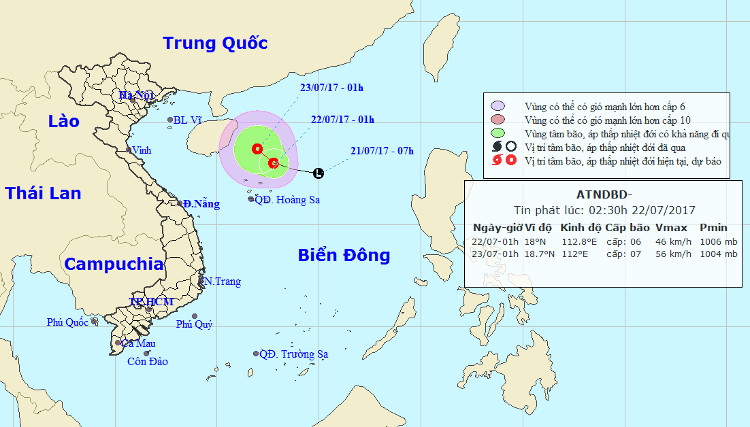
Tropical depressions are gradually stronger in the South China Sea
At 01:00 on July 22, the position of the tropical depression center was about 18.0 degrees north latitude; 112.8 degrees Kinh Dong, about 150km from Hoang Sa archipelago to the Northeast. The strongest wind in the area near the center of strong tropical depression at level 6 (40-50km / hour), shock level 7-8.
It is forecasted that in the next 24 hours, tropical depressions will move slowly in the Northwest direction, about 5km per hour and have more powerful abilities. At 01:00 on July 23, the position of the tropical depression center was about 18.7 degrees North latitude; 112.0 Kinh Dong, about 160km from Hainan Island (China) to the East. The strongest wind in the area near the center of strong tropical low pressure level 7 (50-60km / hour), level 8-9.

Location and path of tropical depressions.
In the next 24 hours , the area is dangerous (strong winds of level 6 or higher, level 8-9, strong seas) from parallel 16.5 to 21.00N; West of meridian 115.00E. Disaster risk level: level 3.
In the next 24 to 48 hours , tropical depressions move in the west-northwest direction, about 5 km per hour and there is also a strong possibility.
Due to the effects of tropical depressions, the North Sea East Sea (including the northern sea of the Paracel Islands) has strong winds of level 6-7, shock levels of 8-9, and strong seas. Disaster risk level: level 3.
In the middle and southern part of the South China Sea (including the waters of the Spratly Islands), the waters from Ninh Thuan to Ca Mau have rainfall and thunderstorms, strong southwest wind level 5, sometimes level 6, level 7-8 shock. ; Ca Mau to Kien Giang and the Gulf of Thailand have showers and strong thunderstorms. In a thunderstorm there is a possibility of tornado and a strong wind of level 6-8. Disaster risk level: level 1.
- Tropical depressions can enter the East Sea in the next 2 days
- Tropical depressions are likely to become strong storms heading into the South China Sea
- Latest news about two tropical depressions consecutively in the South China Sea
- Tropical depressions may intensify into storms when approaching the Spratlys
- Tropical depression at level 8 formed in the South China Sea
- Latest news about tropical depression
- Occurrence of tropical depression near the South China Sea, the possibility of strong storms
- Occurrence of tropical depressions in the East Sea, rainstorms all over the country
- Typhoon has just melted, tropical depressions are about to enter the South China Sea
- Tropical depressions enter the South China Sea, potentially strong into storms
- Vietnam must receive 6-7 storms and tropical depressions
- Tropical depressions change direction, moving north
 Is the magnetic North Pole shift dangerous to humanity?
 Washington legalizes the recycling of human bodies into fertilizer
 Lightning stone - the mysterious guest
 Stunned by the mysterious sunset, strange appearance