A new storm appeared on the east sea, storm Pakhar
Early in the morning (August 25), in a sea off the southeastern island of Lu-Dong (Philippines), a storm with the international name of Pakhar formed.
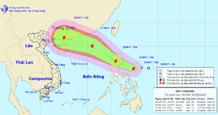
At 4 o'clock , the location of the center of the storm is about 15.2 degrees north latitude; 124.8 Kinh Dong, about 330km east of the island of Lebanon (Philippines) to the Southeast. The strongest wind is in the area near the center of strong storm level 8 (60-75km / hour), level 10 shock.

Location and direction of typhoon Pakhar.(Photo: NCHMF).
It is forecasted that in the next 24 hours , the storm will move mainly in the direction of West Northwest, every hour is 15-20km. At 04:00 on August 26, the location of the storm center is about 16.8 degrees Vi Bac; 121.0 degrees east longitude, right on the central island of Luke (Philippines). The strongest wind in the area near the storm center is strong at level 9 (75-90km / hour), level 11 jerks.
In the next 24 to 48 hours , the storm moved quickly in the Northwest direction, about 25km per hour. At 04:00 on August 27, the location of the storm center is about 20.0 degrees north latitude; 116.0 degrees Kinh Dong, about 600km away from Lei Chau Peninsula (China) to the Southeast. The strongest wind in the area near the center of strong storm level 11 (100-115km / hour), shock level 13.
In the next 48 to 72 hours , the storm moved quickly in the Northwest Northwest, about 25km per hour.
- A new storm appeared near the East Sea
- A strong storm of level 14 appeared in the South China Sea
- Image: Hurricane Pakhar devastates Binh Duong
- Two people died, thousands of houses were blown away by the storm
- Hurricane Pakhar raging in HCMC
- Hurricane Pakhar and tropical depression are
- Tin storm on the East Sea (storm No. 7)
- Storm No. 12 weakens into a tropical depression
- Hurricane Kalmaegi moves at a very fast speed
- New storm appeared on the East Sea
- Tin storm on the East Sea: Typhoon Khanun
- Storm No. 15 has not melted, near the East Sea, a new storm appears
 Is the magnetic North Pole shift dangerous to humanity?
 Washington legalizes the recycling of human bodies into fertilizer
 Lightning stone - the mysterious guest
 Stunned by the mysterious sunset, strange appearance