Marvel at the most accurately drawn Earth map
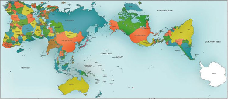
Japanese architect Hajime Narukawa claims to have solved a problem for centuries - how to draw a sphere flattened to Earth on a flat surface.
He claimed the above map, called AuthaGraph World Map , achieved this task.

World Map AuthaGraph.
This Earth Map, first created in 1999, arranges the physical components of the world in a 2D rectangle, trying to describe their relative size as accurately as possible.
By doing so, this map has divided the parts of the world into 96 triangles, making it into a tetrahedron, then opening it to become a rectangle.
Unlike the traditional Mercator maps , made in the 16th century, are said to have overstated the size of northern regions like Greenland and minimized central areas like Africa, World Map AuthaGraph still keep the same area as on 3D map.

World Map AuthaGraph retains the same area as on 3D maps.
This map of the globe recently won a major Japanese design award in 2016, which was established by the Japanese Ministry of International Trade and Industry in 1957.
Users can buy a global version of the map, and can be removed.
- Video: Discover everything about Earth
- The 8 biggest mysteries about Earth
- Mysterious ancient maps
- 15th-century hand-drawn map reveals the end-of-world scenario
- If the Earth suddenly reverses the direction of rotation, we will have an unbelievably good result
- One more proof that China has found America
- Marvel at the mighty universe
- Perspective of the destruction of the earth
- The correct distance from Earth to the nearest galaxy
- Identify asteroids to lead near Earth
- New test methods help treat cancer accurately
- Detecting weird dinosaur fossils in Canada
 'Fine laughs' - Scary and painful torture in ancient times
 The sequence of numbers 142857 of the Egyptian pyramids is known as the strangest number in the world - Why?
 History of the iron
 What is alum?