Researchers have succeeded in creating Mars topographic maps
Thanks to the use of high-resolution holographic shooting data called HRSC equipped with Mars Express Mars probe, scientific researchers have drawn the first walking map of Mars. With detailed high-altitude lines and the names of geographical features of the Iani Chaos region, this map could become a standard reference for future Mars research programs.
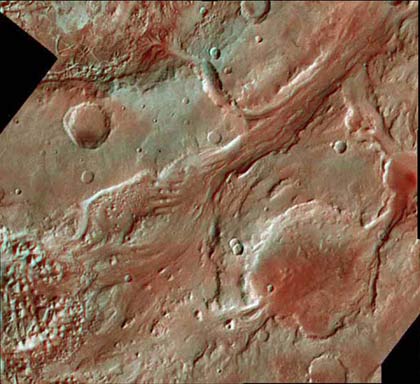
Iani Chaos is a low-lying area with a length of 330 km and a width of 430 km, located at 2.80 South and 342.50 North. The rocks and hills created a kind of faulty and broken terrain with a chaotic distribution. The terraced terrain and the 'stone islands' are the ruins of a collapsed surface after caves are formed below this surface and the ice in these caves has melted due to the volcanic heat and flows through Ares Vallis to the lowlands in the north.

Mars topographic map.The map was drawn by Berlin Technical University in 2006. Image data of MOLA science group.
This map is a topographic map because it uses high-level lines to indicate the elevation of the Iani Chaos lowland.
These high-altitude lines were painted on high-resolution Martian photos taken by high-resolution cameras called HRSC equipped with Mars Express Mars. Maps of this type are often used by hikers and planners.
In the UK, this type of map is called an ordinance survey map. And in every other country it has a different name. High-level lines are determined by HRSC data.
This data has been converted to a three-dimensional model and named the digital terrain model HRSC DTMs.
These new maps were drawn by J. Albertz and S. Gehrke of the Geographic Information and Science Institute under the direction of lead investigator G. Neukum and were part of the department's effort. belongs to the HRSC experiment program with the cooperation of the German Aerospace Center (DLR), the Planet Research Institute in Berlin city.
They used HRSC digital terrain model DTMs to Iani Chaos area to create a series of topographic maps with different ratios ranging from 1: 200000 to 1: 50000 scale
The reason why the researchers chose Iani Chaos is because of the importance of its terrain. It is covered by separate lands and hills that have created a chaotic terrain spread throughout the region.
These " stone islands " are the remnants of a previous type of Mars surface . The lands between the stone islands collapsed when the caves were formed under them. Initially, the caves were filled with ice that then melted due to the heat of volcanic activities. When water flows through the Ares Vallis region to the lowlands to the north of Mars, the region collapsed and created the Iani Chaos region as it is today.
High-altitude lines help us understand the shape and structure of the surface shown in the pictures. In most maps, each high-altitude line has a height difference of 250m. These maps also indicate the geographical features and the meridians and latitudes of Mars.
These maps are proof of a product that can be created from the HRSC test program. This experimental program is in the final stages of providing sufficient data to create such maps of the entire surface of Mars. This program will create 10,372 maps like that, each map will cover an equal area of the surface of Mars with a ratio of 1: 200000.
3D image of Iani Chaos area (Photo: fourth-millennium)
Up to now, some of the first sample maps within the framework of the funding of the HRSC program in Germany have been completed. Mass production of maps can only be done internally in the planetary mapping program at the European level.
Gerhard Neukum, of Freie University in Berlin, Germany, is the principal investigator of the HRSC experiment program. The research team consists of 45 scientists from 32 research institutes in 10 countries around the world. The HRSC program was developed under the direction of the German Aerospace Center in cooperation with businesses in this field such as EADS Astrium, Lewicki Microelectronic GmbH and Jena-Optronik GmbH.
The Kiet
- Map reveals the location of bacteria and chemicals on the human body
- How to see the Moon, Mars with Google Maps
- Mysterious ancient maps
- China completed the most obvious 3D Moon map
- Mars used to have rain
- Japan: Creating iron-rich rice varieties with high productivity
- The island of Mars is right on Earth
- Mars for everyone
- The oldest map in the world sells for 8.5 billion
- How does Google Maps work?
- Google Maps detects 8 strange bases of aliens?
- Elon Musk wants to put the artificial sun on Mars
 Van Allen's belt and evidence that the Apollo 11 mission to the Moon was myth
 The levels of civilization in the universe (Kardashev scale)
 Today Mars, the sun and the Earth are aligned
 The Amazon owner announced a secret plan to build a space base for thousands of people