Satellites help locate water sources
Like most sub-Saharan African countries, Niger has many problems in securing water demand. As part of ESA's TIGER solution, satellite data is being used to identify groundwater resources in countries with frequent droughts.
Because of the variation in rainfall, in recent years the industry has faced many difficulties in ensuring food security in the Sahel region.
ESA's WADE Project (Program for finding water in desert or arid lands in West Africa Ecosystem), funded by Data User Element, uses ERS and Multi-purpose Open Envisat (SAR) to map and control the location and extension of surface waters to identify areas of water penetration.
Using these maps will help local governments better manage their water resources, bring animals closer to water sources and improve water storage capacity.
Advanced computer system (ACS spa) in Rome, Italy, developed the WADE system with local users, represented by AGRHYMET (the Federal Commission for the Executive of the Permanent Drought in Sahel) .
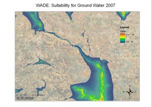 Map of groundwater capacity around Niamey area in 2007. (Photo: Advanced Computer Systems SpA)
To demonstrate this technology, ERS and Envisat SAR data from 1993 to 2007 were combined with data on a 100-square-kilometer area in western Niger. Based on these data, a water area classification map is created for each year.The results were evaluated based on 90 samples collected by AGRHYMET in the summer of 2007 and showed 100% accuracy for fixed water sources and 75% for semi-permanent water sources.
Issifou Alfari, head of AGRHYMET's Department of Water Resources and Desertification, said: 'Controlling fixed and semi-permanent water sources is essential for grazing activities and irrigation areas. in the near dry areas. We are very pleased with the scope and results of the project, and we believe that this source of information will be the basis for water control activities. '
In November 2008, WADE software and data were installed at AGRHYMET's facility, in Niamey, capital of Niger. Through training courses, AGRHYMET employees are currently using this system to perform their management work.
Alfari said: 'The WADE system is suitable for the normal operation of AGRHYMET, especially providing accurate water resource management information at the regional and national level'.
ESA started the TIGER solution in 2002 to exploit Earth Observation (EO) technology that addresses the need for information on urgent water resources in Africa.
WADE is one of TIGER's five projects, using the most advanced EO technology to develop innovative, low-cost solutions to help the African government in controlling scarce water resources.
- Discover new sources of pollution with NASA satellites
- Panic because of water poisoning
- Most surface water sources in Ho Chi Minh City have been polluted
- Clean water and numbers to speak
- 50% of the world's population lacks fresh water by 2050
- SpaceX brought two satellites to monitor the Earth's water level on the universe
- Harm of polluted water
- How much arsenic in water is dangerous?
- Vietnamese groundwater resources decline
- Strange energy sources
- Find water sources in Con Dao
- Identify molecules sensitive to CO2 in insects
 Is the magnetic North Pole shift dangerous to humanity?
 Washington legalizes the recycling of human bodies into fertilizer
 Lightning stone - the mysterious guest
 Stunned by the mysterious sunset, strange appearance