Strong Banyan storm level 8 on the East Sea
Currently, in the region of the Central Islands of the Philippines there is an active storm with the international name of BANYAN.
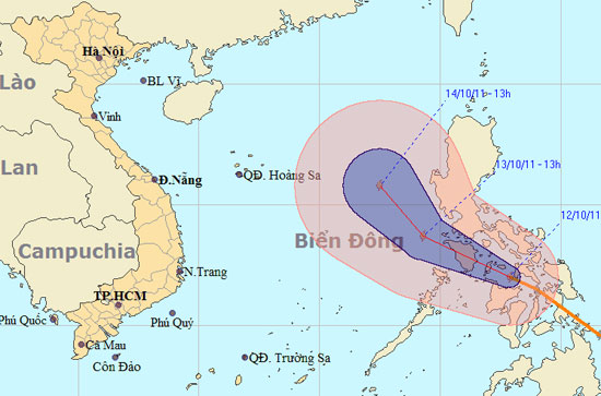
At 13 o'clock on October 12, the location of the center of the storm is about 12.0 degrees north latitude; 122.9 Kinh Dong. The strongest wind is in the area near strong storm level 8 (ie 62 to 74 km per hour), level 9 and level 10 jerks.

The path and location of the storm Banyan. Click on the larger image
It is forecasted that in the next 24 hours, the storm will move in the direction between Northwest and West Northwest, about 15km per hour. By 13:00 on October 13, the location of the center of the storm was about 13.7 degrees Vi Bac; 119.3 degrees east longitude, on the eastern sea of the East Sea. The strongest winds in the area near the storm center are strong at level 8 (ie 62 to 74 km per hour), level 9 and level 10 jerks.
In the next 24 to 48 hours, the storm moves in the direction between Northwest and West Northwest, about 10 - 15 km per hour . By 13:00 on October 14, the location of the center of the storm was about 15.8 degrees Vi Bac; 117.5 degrees east longitude, about 600km from Hoang Sa archipelago to the southeast of Southeast. The strongest winds in the area near the storm center are strong at level 8 (ie 62 to 74 km per hour), level 9 and level 10 jerks.
In the next 48 to 72 hours, the storm moved in the Northwest direction, about 10 - 15 km per hour.
Due to the impact of storms, from tomorrow morning (October 13), the East Sea in the North and the Middle Sea has strong winds gradually up to level 6, level 7, near the storm center level 8, level 9, level 10. The sea is very strong.
News broadcast at: 14:30
- Bopha storm is active strongly near the South China Sea
- Strong tropical depression into a storm near the East Sea
- Prohibition of boats in the Gulf of Tonkin, coping with storm No. 3
- Location and direction of storm No. 3
- A strong storm of level 14 appeared in the South China Sea
- Tin storm on the East Sea
- Tin storm near the east sea
- Tin storm on the East Sea (Storm No. 5) - Update
- Tin storm on the East Sea (Storm Nesat)
- Influence of super typhoon, East Sea is about to have strong winds
- Tin storm on the East Sea (Storm No. 5)
- Aere storm entered the South China Sea
 Is the magnetic North Pole shift dangerous to humanity?
 Washington legalizes the recycling of human bodies into fertilizer
 Lightning stone - the mysterious guest
 Stunned by the mysterious sunset, strange appearance