The earthquake 'rocked' the scientific world
60 years ago, the largest earthquake in American history stunned geologists .
This natural disaster still drives scientific discoveries in today's world.
From theory to practice

The earthquake is evidence for the theory of plate tectonics.
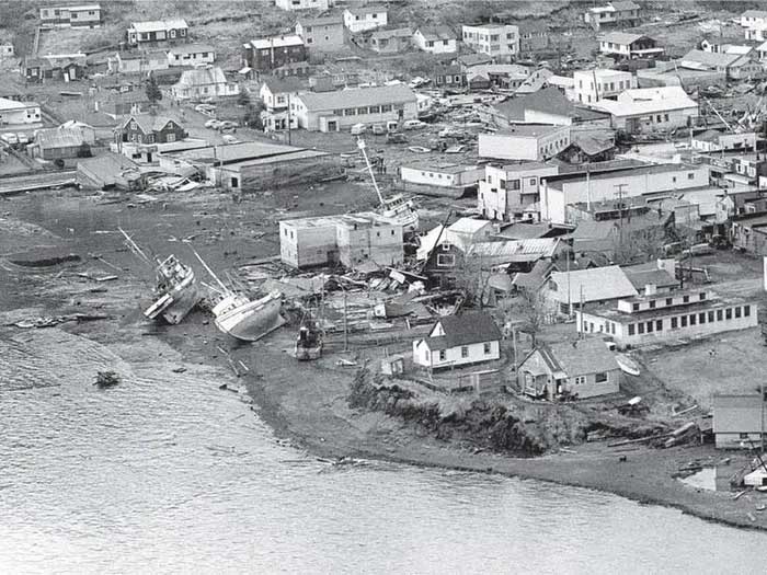
On March 27, 1964 , the largest earthquake in American history and the second strongest in the world occurred in the state of Alaska with an intensity of 9.2 on the Richter scale. In the city of Anchorage, streets were divided in half, and even a neighborhood sank into the sea.
Along the Alaskan coast, massive tsunamis destroyed ports and swept away villages. Businesses left their headquarters, people had to relocate and rebuild. The disaster caused $3 billion in damage to the entire state.
Perhaps the most serious and lasting impact of the earthquake, however, was on science. This disaster reshaped humanity's understanding of earthquakes , tsunamis, and the land beneath our feet. Today, scientists still study the impact of earthquakes on natural life.
Immediately after the disaster, the US Geological Survey sent field geologists to Alaska to investigate the earthquake's origin. Over weeks and months, scientists carefully measured the impact on the landscape and found large swaths of Alaska experienced permanent uplift or lowering as the ground shook.
For example, a section of coast near Kodiak has risen about 9 meters. More than 300km northeast of Anchorage, the ground sank about 3m deep. These results were the first real evidence of plate tectonics. Accordingly, the Earth's crust is made up of tectonic plates that do not stand still but move. Earthquakes cause plates to collide with each other, separate or overlap.
Before the 1964 earthquake, scientists lacked the data needed to prove the existence of subduction zones, where one tectonic plate sinks beneath another. But after the earthquake, they had clear evidence of plate tectonics.
Based on ideas about plate tectonics and uplift and subsidence data, geologists went upstream and accurately determined that two tectonic plates had slid up to 18m along the subduction zone and caused the earthquake. Scientists also made many advances in the field of geophysics, helping them understand the Earth's motion processes.
Researchers are building a global network of seismometers, measuring ground movements, and monitoring nuclear weapons testing. These tools also have the side benefit of collecting earthquake data.
In addition, researchers have also developed techniques to date identical rocks found on different continents and demonstrate that they have separated and moved great distances across the world. tectonic plates for millions of years.
Since this technology was born, scientists have discovered many subduction zones in Indonesia, Japan, and Chile - where major earthquakes occurred afterward. 'I think it's fair to say that the 1964 earthquake was an important part of converting the theory of plate tectonics to the reality of plate tectonics , ' said Alaska State seismologist Michael West. know.

The 1964 earthquake caused heavy damage to the state of Alaska, USA.
Earthquake history
Besides the issue of plate tectonics, scientists also discovered a history of earthquakes in Alaska. Coastal forests in areas with sudden subsidence have been flooded with seawater.
When field scientists dug into the mud in those forests, they discovered alternating layers of buried plants and ocean sediments. This shows that the areas that subsided in 1964 had subsided many times before in large earthquakes lasting thousands of years.
Forests grow. Earthquakes occurred, forests were submerged and covered with ocean sediment. Then the forest grew again.
By drilling sediment cores deep in these forests and using new techniques to date the layers of organic material inside, scientists detect earthquakes going back millennia . From there, the field of paleoseismology was born.
When they repeated this method in the Pacific Northwest, they discovered that the Cascadia subduction zone off the West Coast of the United States has caused large earthquakes in the past. This area will experience earthquakes in the future.
Paleoseismology was born and formed the basis for the National Seismic Hazard Map of the US Geological Survey. It includes estimates of the probability of earthquakes occurring across the country. Governments and companies rely on these maps to figure out where it's safe to build, what types of buildings to build, and insurance costs.
The event in Alaska also helped scientists clearly understand the impact of landslides during earthquakes, thereby monitoring tsunami risks. In addition, scientists warn that tsunamis can carry organisms containing pathogens inland. However, no one can predict this incident to develop prevention measures.
- 6.1 Richter earthquake rocked Taiwan
- Earthquake shook Japan
- Nearly 250 people were injured by earthquakes in Pakistan
- Greece was shaken by an earthquake of 6.2 on the Richter scale
- Strong earthquakes along the Pacific Ocean, hundreds of casualties
- Strong earthquakes rocked Greece, Nicaragua
- The biggest earthquakes in history
- Strong earthquake near Samoa
- The earthquake rocked Taipei
- 30 earthquakes shook the island of Japan
- The powerful 7.1 earthquake quake Papua New Guinea
- Earthquakes in the Philippines and Indonesia
 'Fine laughs' - Scary and painful torture in ancient times
 The sequence of numbers 142857 of the Egyptian pyramids is known as the strangest number in the world - Why?
 History of the iron
 What is alum?